You are here: Home > Network List > US - United States National Seismic Network Stations List
> Station DUG Dugway, Tooele County, Utah, USA > Earthquake Result Viewer
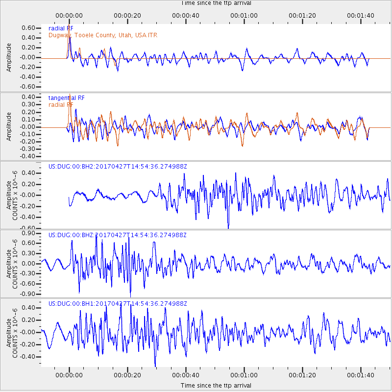
DUG Dugway, Tooele County, Utah, USA - Earthquake Result Viewer
*The percent match for this event was below the threshold and hence no stack was calculated.
| Earthquake location: |
Rat Islands, Aleutian Islands |
| Earthquake latitude/longitude: |
51.3/178.6 |
| Earthquake time(UTC): |
2017/04/27 (117) 14:46:33 GMT |
| Earthquake Depth: |
19 km |
| Earthquake Magnitude: |
5.7 Mww |
| Earthquake Catalog/Contributor: |
NEIC PDE/us |
|
| Network: |
US United States National Seismic Network |
| Station: |
DUG Dugway, Tooele County, Utah, USA |
| Lat/Lon: |
40.19 N/112.81 W |
| Elevation: |
1477 m |
|
| Distance: |
47.5 deg |
| Az: |
75.36 deg |
| Baz: |
307.465 deg |
| Ray Param: |
$rayparam |
*The percent match for this event was below the threshold and hence was not used in the summary stack. |
|
| Radial Match: |
67.029816 % |
| Radial Bump: |
400 |
| Transverse Match: |
56.23451 % |
| Transverse Bump: |
400 |
| SOD ConfigId: |
2028011 |
| Insert Time: |
2017-05-11 14:52:52.610 +0000 |
| GWidth: |
2.5 |
| Max Bumps: |
400 |
| Tol: |
0.001 |
|
Signal To Noise
| Channel | StoN | STA | LTA |
| US:DUG:00:BHZ:20170427T14:54:36.274988Z | 3.8529882 | 3.1705414E-7 | 8.2287855E-8 |
| US:DUG:00:BH1:20170427T14:54:36.274988Z | 1.3487881 | 1.4106001E-7 | 1.0458278E-7 |
| US:DUG:00:BH2:20170427T14:54:36.274988Z | 1.9486632 | 1.15414736E-7 | 5.9227645E-8 |
| Arrivals |
| Ps | |
| PpPs | |
| PsPs/PpSs | |


