You are here: Home > Network List > TS - TERRAscope (Southern California Seismic Network) Stations List
> Station PFO Pinon Flat, California, USA > Earthquake Result Viewer
PFO Pinon Flat, California, USA - Earthquake Result Viewer
| Earthquake location: |
Tonga Islands |
| Earthquake latitude/longitude: |
-18.0/-173.7 |
| Earthquake time(UTC): |
1991/01/08 (008) 22:04:10 GMT |
| Earthquake Depth: |
43 km |
| Earthquake Magnitude: |
6.1 MB, 6.0 MS, 6.3 UNKNOWN |
| Earthquake Catalog/Contributor: |
WHDF/NEIC |
|
| Network: |
TS TERRAscope (Southern California Seismic Network) |
| Station: |
PFO Pinon Flat, California, USA |
| Lat/Lon: |
33.61 N/116.46 W |
| Elevation: |
1280 m |
|
| Distance: |
74.9 deg |
| Az: |
46.608 deg |
| Baz: |
235.953 deg |
| Ray Param: |
0.051959835 |
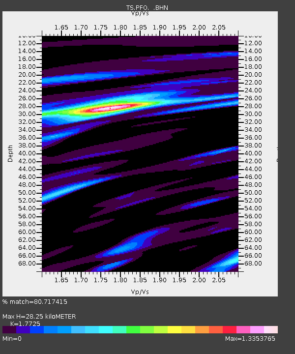
| Estimated Moho Depth: |
28.25 km |
| Estimated Crust Vp/Vs: |
1.77 |
| Assumed Crust Vp: |
6.264 km/s |
| Estimated Crust Vs: |
3.534 km/s |
| Estimated Crust Poisson's Ratio: |
0.27 |
|
| Radial Match: |
80.717415 % |
| Radial Bump: |
400 |
| Transverse Match: |
64.40762 % |
| Transverse Bump: |
400 |
| SOD ConfigId: |
16938 |
| Insert Time: |
2010-02-26 14:41:17.567 +0000 |
| GWidth: |
2.5 |
| Max Bumps: |
400 |
| Tol: |
0.001 |
|
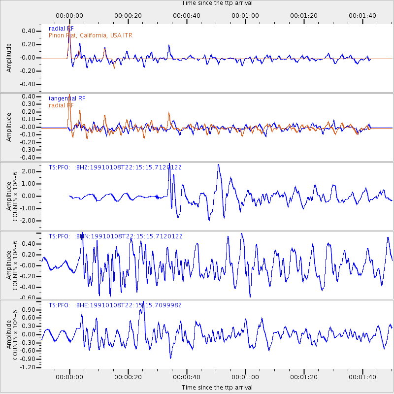
Signal To Noise
| Channel | StoN | STA | LTA |
| TS:PFO: :BHN:19910108T22:15:15.712012Z | 1.3381342 | 2.2356728E-7 | 1.670739E-7 |
| TS:PFO: :BHE:19910108T22:15:15.709998Z | 1.7862505 | 2.8807074E-7 | 1.6127119E-7 |
| TS:PFO: :BHZ:19910108T22:15:15.712012Z | 4.835161 | 8.214263E-7 | 1.6988601E-7 |
| Arrivals |
| Ps | 3.6 SECOND |
| PpPs | 12 SECOND |
| PsPs/PpSs | 16 SECOND |


