You are here: Home > Network List > UW - Pacific Northwest Regional Seismic Network Stations List
> Station WOLL Wollman Farm, Schrag, WA, USA > Earthquake Result Viewer
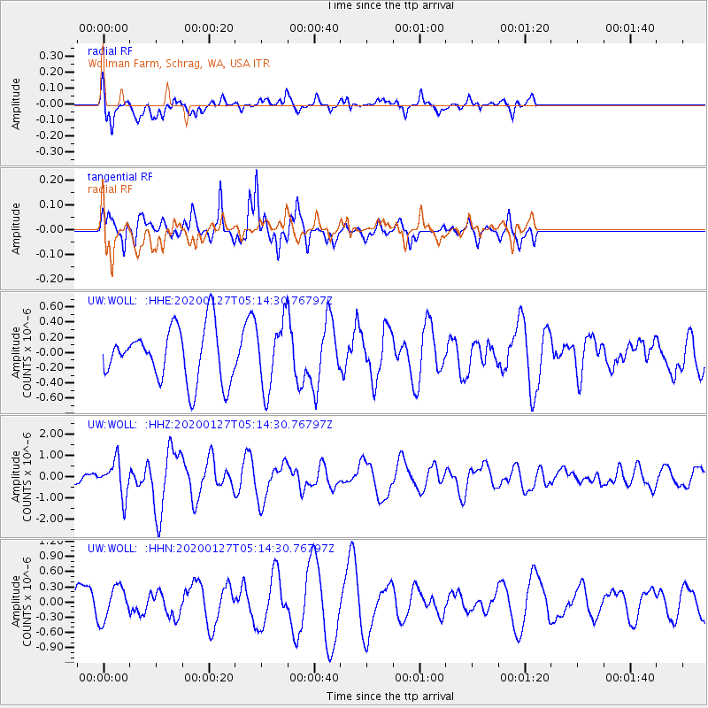
WOLL Wollman Farm, Schrag, WA, USA - Earthquake Result Viewer
*The percent match for this event was below the threshold and hence no stack was calculated.
| Earthquake location: |
Solomon Islands |
| Earthquake latitude/longitude: |
-10.1/161.0 |
| Earthquake time(UTC): |
2020/01/27 (027) 05:02:01 GMT |
| Earthquake Depth: |
18 km |
| Earthquake Magnitude: |
6.3 Mww |
| Earthquake Catalog/Contributor: |
NEIC PDE/us |
|
| Network: |
UW Pacific Northwest Regional Seismic Network |
| Station: |
WOLL Wollman Farm, Schrag, WA, USA |
| Lat/Lon: |
47.06 N/118.92 W |
| Elevation: |
385 m |
|
| Distance: |
90.6 deg |
| Az: |
42.336 deg |
| Baz: |
255.918 deg |
| Ray Param: |
$rayparam |
*The percent match for this event was below the threshold and hence was not used in the summary stack. |
|
| Radial Match: |
45.316734 % |
| Radial Bump: |
345 |
| Transverse Match: |
73.17383 % |
| Transverse Bump: |
267 |
| SOD ConfigId: |
20465011 |
| Insert Time: |
2020-02-10 05:19:17.091 +0000 |
| GWidth: |
2.5 |
| Max Bumps: |
400 |
| Tol: |
0.001 |
|
Signal To Noise
| Channel | StoN | STA | LTA |
| UW:WOLL: :HHZ:20200127T05:14:30.76797Z | 2.716514 | 8.193899E-7 | 3.0163287E-7 |
| UW:WOLL: :HHN:20200127T05:14:30.76797Z | 1.3125397 | 3.2904381E-7 | 2.5069247E-7 |
| UW:WOLL: :HHE:20200127T05:14:30.76797Z | 1.232106 | 4.3364304E-7 | 3.519527E-7 |
| Arrivals |
| Ps | |
| PpPs | |
| PsPs/PpSs | |


