You are here: Home > Network List > AV - Alaska Volcano Observatory Stations List
> Station SPCR Ckakachatna River, Mount Spurr, Alaska > Earthquake Result Viewer
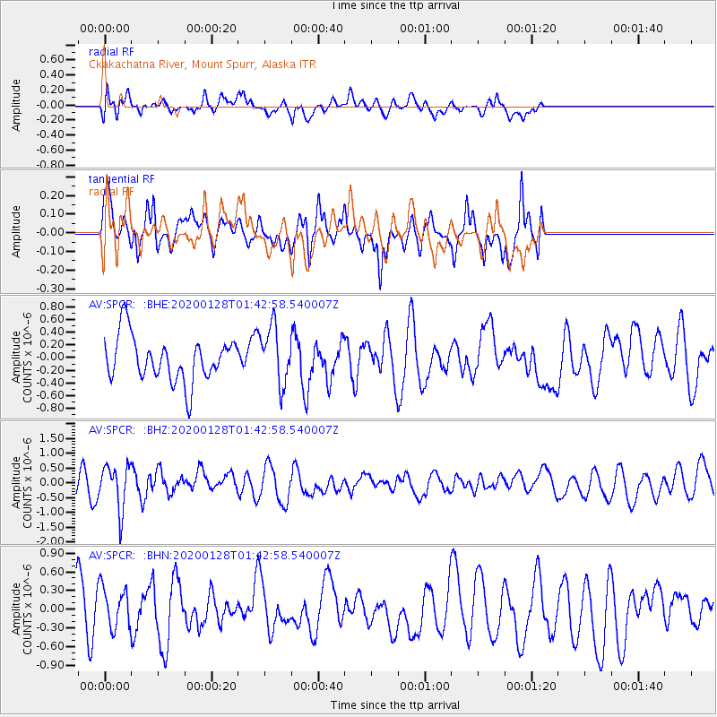
SPCR Ckakachatna River, Mount Spurr, Alaska - Earthquake Result Viewer
*The percent match for this event was below the threshold and hence no stack was calculated.
| Earthquake location: |
Hokkaido, Japan Region |
| Earthquake latitude/longitude: |
43.6/145.9 |
| Earthquake time(UTC): |
2020/01/28 (028) 01:36:02 GMT |
| Earthquake Depth: |
79 km |
| Earthquake Magnitude: |
5.5 mb |
| Earthquake Catalog/Contributor: |
NEIC PDE/us |
|
| Network: |
AV Alaska Volcano Observatory |
| Station: |
SPCR Ckakachatna River, Mount Spurr, Alaska |
| Lat/Lon: |
61.20 N/152.21 W |
| Elevation: |
984 m |
|
| Distance: |
39.9 deg |
| Az: |
41.701 deg |
| Baz: |
272.889 deg |
| Ray Param: |
$rayparam |
*The percent match for this event was below the threshold and hence was not used in the summary stack. |
|
| Radial Match: |
42.980602 % |
| Radial Bump: |
400 |
| Transverse Match: |
53.861736 % |
| Transverse Bump: |
400 |
| SOD ConfigId: |
20465011 |
| Insert Time: |
2020-02-11 01:39:06.524 +0000 |
| GWidth: |
2.5 |
| Max Bumps: |
400 |
| Tol: |
0.001 |
|
Signal To Noise
| Channel | StoN | STA | LTA |
| AV:SPCR: :BHZ:20200128T01:42:58.540007Z | 1.9329796 | 7.505394E-7 | 3.8828108E-7 |
| AV:SPCR: :BHN:20200128T01:42:58.540007Z | 0.91264856 | 3.34202E-7 | 3.6618914E-7 |
| AV:SPCR: :BHE:20200128T01:42:58.540007Z | 1.2916205 | 4.5321406E-7 | 3.5088794E-7 |
| Arrivals |
| Ps | |
| PpPs | |
| PsPs/PpSs | |


