You are here: Home > Network List > CN - Canadian National Seismograph Network Stations List
> Station INK INUVIK, NT > Earthquake Result Viewer
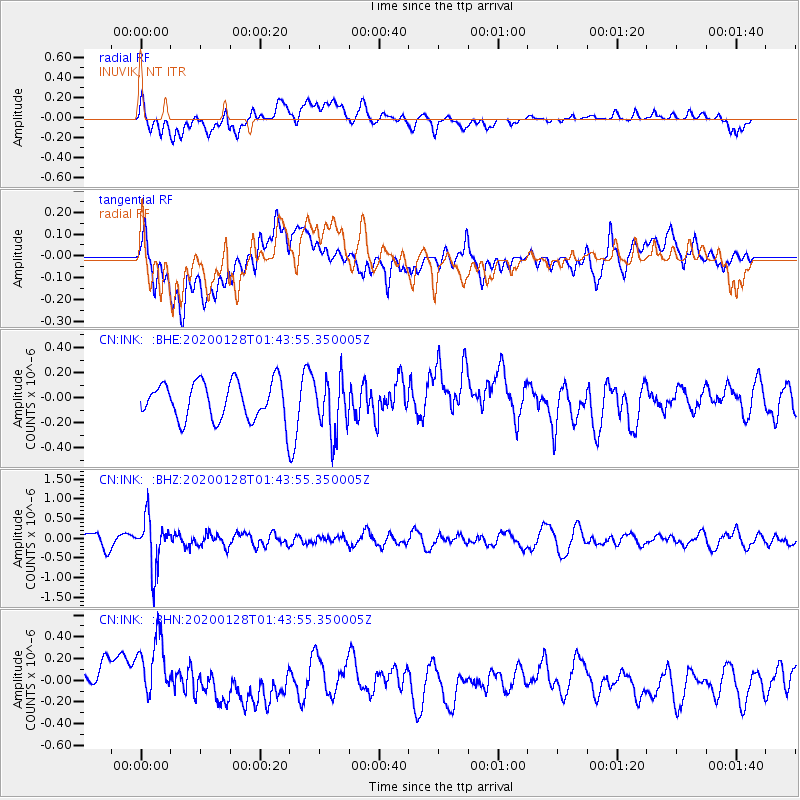
INK INUVIK, NT - Earthquake Result Viewer
*The percent match for this event was below the threshold and hence no stack was calculated.
| Earthquake location: |
Hokkaido, Japan Region |
| Earthquake latitude/longitude: |
43.6/145.9 |
| Earthquake time(UTC): |
2020/01/28 (028) 01:36:02 GMT |
| Earthquake Depth: |
79 km |
| Earthquake Magnitude: |
5.5 mb |
| Earthquake Catalog/Contributor: |
NEIC PDE/us |
|
| Network: |
CN Canadian National Seismograph Network |
| Station: |
INK INUVIK, NT |
| Lat/Lon: |
68.31 N/133.53 W |
| Elevation: |
44 m |
|
| Distance: |
47.0 deg |
| Az: |
30.091 deg |
| Baz: |
281.371 deg |
| Ray Param: |
$rayparam |
*The percent match for this event was below the threshold and hence was not used in the summary stack. |
|
| Radial Match: |
41.76663 % |
| Radial Bump: |
400 |
| Transverse Match: |
37.192562 % |
| Transverse Bump: |
400 |
| SOD ConfigId: |
20465011 |
| Insert Time: |
2020-02-11 01:42:04.488 +0000 |
| GWidth: |
2.5 |
| Max Bumps: |
400 |
| Tol: |
0.001 |
|
Signal To Noise
| Channel | StoN | STA | LTA |
| CN:INK: :BHZ:20200128T01:43:55.350005Z | 4.007685 | 6.1915443E-7 | 1.544918E-7 |
| CN:INK: :BHN:20200128T01:43:55.350005Z | 2.284101 | 3.4421257E-7 | 1.5069936E-7 |
| CN:INK: :BHE:20200128T01:43:55.350005Z | 1.4707422 | 2.2030834E-7 | 1.4979399E-7 |
| Arrivals |
| Ps | |
| PpPs | |
| PsPs/PpSs | |


