You are here: Home > Network List > TS - TERRAscope (Southern California Seismic Network) Stations List
> Station PFO Pinon Flat, California, USA > Earthquake Result Viewer
PFO Pinon Flat, California, USA - Earthquake Result Viewer
| Earthquake location: |
Bering Sea |
| Earthquake latitude/longitude: |
58.4/-175.4 |
| Earthquake time(UTC): |
1991/02/21 (052) 02:35:32 GMT |
| Earthquake Depth: |
10 km |
| Earthquake Magnitude: |
6.3 MB, 6.5 MS, 6.7 UNKNOWN |
| Earthquake Catalog/Contributor: |
WHDF/NEIC |
|
| Network: |
TS TERRAscope (Southern California Seismic Network) |
| Station: |
PFO Pinon Flat, California, USA |
| Lat/Lon: |
33.61 N/116.46 W |
| Elevation: |
1280 m |
|
| Distance: |
46.0 deg |
| Az: |
96.038 deg |
| Baz: |
321.164 deg |
| Ray Param: |
0.07092008 |
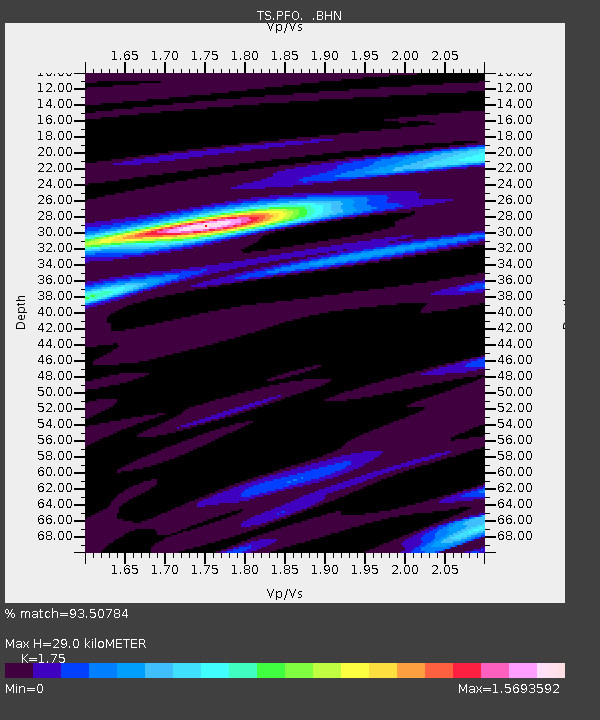
| Estimated Moho Depth: |
29.0 km |
| Estimated Crust Vp/Vs: |
1.75 |
| Assumed Crust Vp: |
6.264 km/s |
| Estimated Crust Vs: |
3.579 km/s |
| Estimated Crust Poisson's Ratio: |
0.26 |
|
| Radial Match: |
93.50784 % |
| Radial Bump: |
397 |
| Transverse Match: |
89.11111 % |
| Transverse Bump: |
400 |
| SOD ConfigId: |
16938 |
| Insert Time: |
2010-02-26 14:41:19.604 +0000 |
| GWidth: |
2.5 |
| Max Bumps: |
400 |
| Tol: |
0.001 |
|
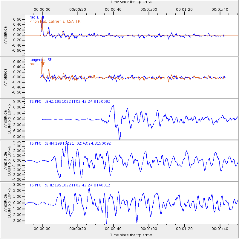
Signal To Noise
| Channel | StoN | STA | LTA |
| TS:PFO: :BHN:19910221T02:43:24.815009Z | 0.9162628 | 9.9645206E-8 | 1.0875177E-7 |
| TS:PFO: :BHE:19910221T02:43:24.814001Z | 1.3429946 | 1.8169446E-7 | 1.3529055E-7 |
| TS:PFO: :BHZ:19910221T02:43:24.815009Z | 2.0891294 | 3.0054503E-7 | 1.4386137E-7 |
| Arrivals |
| Ps | 3.7 SECOND |
| PpPs | 12 SECOND |
| PsPs/PpSs | 16 SECOND |


