You are here: Home > Network List > TA - USArray Transportable Network (new EarthScope stations) Stations List
> Station A21K Barrow, AK, USA > Earthquake Result Viewer
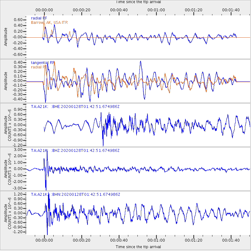
A21K Barrow, AK, USA - Earthquake Result Viewer
*The percent match for this event was below the threshold and hence no stack was calculated.
| Earthquake location: |
Hokkaido, Japan Region |
| Earthquake latitude/longitude: |
43.6/145.9 |
| Earthquake time(UTC): |
2020/01/28 (028) 01:36:02 GMT |
| Earthquake Depth: |
79 km |
| Earthquake Magnitude: |
5.5 mb |
| Earthquake Catalog/Contributor: |
NEIC PDE/us |
|
| Network: |
TA USArray Transportable Network (new EarthScope stations) |
| Station: |
A21K Barrow, AK, USA |
| Lat/Lon: |
71.32 N/156.62 W |
| Elevation: |
577 m |
|
| Distance: |
39.1 deg |
| Az: |
25.505 deg |
| Baz: |
256.312 deg |
| Ray Param: |
$rayparam |
*The percent match for this event was below the threshold and hence was not used in the summary stack. |
|
| Radial Match: |
57.438866 % |
| Radial Bump: |
400 |
| Transverse Match: |
73.99105 % |
| Transverse Bump: |
400 |
| SOD ConfigId: |
20465011 |
| Insert Time: |
2020-02-11 01:51:02.258 +0000 |
| GWidth: |
2.5 |
| Max Bumps: |
400 |
| Tol: |
0.001 |
|
Signal To Noise
| Channel | StoN | STA | LTA |
| TA:A21K: :BHZ:20200128T01:42:51.674986Z | 7.7485585 | 1.1035626E-6 | 1.4242165E-7 |
| TA:A21K: :BHN:20200128T01:42:51.674986Z | 3.5998387 | 5.155622E-7 | 1.4321813E-7 |
| TA:A21K: :BHE:20200128T01:42:51.674986Z | 2.18672 | 3.8433205E-7 | 1.7575734E-7 |
| Arrivals |
| Ps | |
| PpPs | |
| PsPs/PpSs | |


