You are here: Home > Network List > TS - TERRAscope (Southern California Seismic Network) Stations List
> Station PFO Pinon Flat, California, USA > Earthquake Result Viewer
PFO Pinon Flat, California, USA - Earthquake Result Viewer
| Earthquake location: |
Costa Rica |
| Earthquake latitude/longitude: |
10.2/-85.1 |
| Earthquake time(UTC): |
1991/03/16 (075) 06:02:10 GMT |
| Earthquake Depth: |
30 km |
| Earthquake Magnitude: |
5.3 MB, 6.2 MS, 6.2 UNKNOWN |
| Earthquake Catalog/Contributor: |
WHDF/NEIC |
|
| Network: |
TS TERRAscope (Southern California Seismic Network) |
| Station: |
PFO Pinon Flat, California, USA |
| Lat/Lon: |
33.61 N/116.46 W |
| Elevation: |
1280 m |
|
| Distance: |
37.0 deg |
| Az: |
313.879 deg |
| Baz: |
121.76 deg |
| Ray Param: |
0.076328844 |
| Estimated Moho Depth: |
13.25 km |
| Estimated Crust Vp/Vs: |
1.60 |
| Assumed Crust Vp: |
6.264 km/s |
| Estimated Crust Vs: |
3.915 km/s |
| Estimated Crust Poisson's Ratio: |
0.18 |
|
| Radial Match: |
87.65195 % |
| Radial Bump: |
314 |
| Transverse Match: |
72.05845 % |
| Transverse Bump: |
400 |
| SOD ConfigId: |
16938 |
| Insert Time: |
2010-02-26 14:41:22.631 +0000 |
| GWidth: |
2.5 |
| Max Bumps: |
400 |
| Tol: |
0.001 |
|
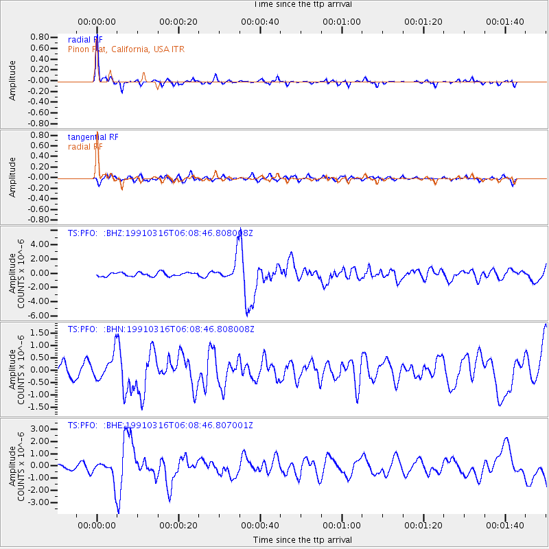
Signal To Noise
| Channel | StoN | STA | LTA |
| TS:PFO: :BHN:19910316T06:08:46.808008Z | 2.5230012 | 5.605263E-7 | 2.2216649E-7 |
| TS:PFO: :BHE:19910316T06:08:46.807001Z | 7.300449 | 9.4571413E-7 | 1.2954192E-7 |
| TS:PFO: :BHZ:19910316T06:08:46.808008Z | 6.7882185 | 1.8008984E-6 | 2.6529764E-7 |
| Arrivals |
| Ps | 1.4 SECOND |
| PpPs | 5.1 SECOND |
| PsPs/PpSs | 6.5 SECOND |


