You are here: Home > Network List > TA - USArray Transportable Network (new EarthScope stations) Stations List
> Station C16K Lisburne Hills, AK, USA > Earthquake Result Viewer
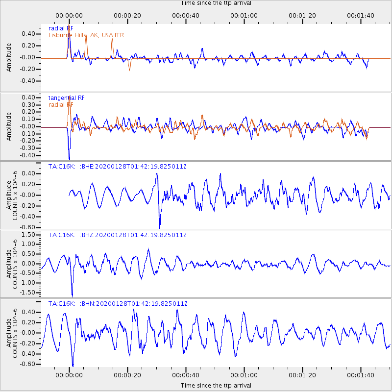
C16K Lisburne Hills, AK, USA - Earthquake Result Viewer
*The percent match for this event was below the threshold and hence no stack was calculated.
| Earthquake location: |
Hokkaido, Japan Region |
| Earthquake latitude/longitude: |
43.6/145.9 |
| Earthquake time(UTC): |
2020/01/28 (028) 01:36:02 GMT |
| Earthquake Depth: |
79 km |
| Earthquake Magnitude: |
5.5 mb |
| Earthquake Catalog/Contributor: |
NEIC PDE/us |
|
| Network: |
TA USArray Transportable Network (new EarthScope stations) |
| Station: |
C16K Lisburne Hills, AK, USA |
| Lat/Lon: |
68.27 N/165.34 W |
| Elevation: |
102 m |
|
| Distance: |
35.3 deg |
| Az: |
28.935 deg |
| Baz: |
250.857 deg |
| Ray Param: |
$rayparam |
*The percent match for this event was below the threshold and hence was not used in the summary stack. |
|
| Radial Match: |
53.64418 % |
| Radial Bump: |
372 |
| Transverse Match: |
68.24184 % |
| Transverse Bump: |
400 |
| SOD ConfigId: |
20465011 |
| Insert Time: |
2020-02-11 01:51:09.973 +0000 |
| GWidth: |
2.5 |
| Max Bumps: |
400 |
| Tol: |
0.001 |
|
Signal To Noise
| Channel | StoN | STA | LTA |
| TA:C16K: :BHZ:20200128T01:42:19.825011Z | 2.694506 | 5.085115E-7 | 1.887216E-7 |
| TA:C16K: :BHN:20200128T01:42:19.825011Z | 1.1641791 | 2.7047588E-7 | 2.3233183E-7 |
| TA:C16K: :BHE:20200128T01:42:19.825011Z | 2.0729089 | 2.4076272E-7 | 1.1614728E-7 |
| Arrivals |
| Ps | |
| PpPs | |
| PsPs/PpSs | |


