You are here: Home > Network List > TA - USArray Transportable Network (new EarthScope stations) Stations List
> Station E18K Tukpahlearik Creek, AK, USA > Earthquake Result Viewer
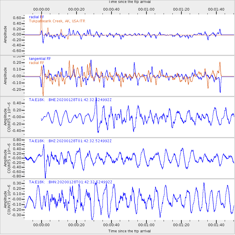
E18K Tukpahlearik Creek, AK, USA - Earthquake Result Viewer
*The percent match for this event was below the threshold and hence no stack was calculated.
| Earthquake location: |
Hokkaido, Japan Region |
| Earthquake latitude/longitude: |
43.6/145.9 |
| Earthquake time(UTC): |
2020/01/28 (028) 01:36:02 GMT |
| Earthquake Depth: |
79 km |
| Earthquake Magnitude: |
5.5 mb |
| Earthquake Catalog/Contributor: |
NEIC PDE/us |
|
| Network: |
TA USArray Transportable Network (new EarthScope stations) |
| Station: |
E18K Tukpahlearik Creek, AK, USA |
| Lat/Lon: |
67.42 N/160.60 W |
| Elevation: |
297 m |
|
| Distance: |
36.8 deg |
| Az: |
31.177 deg |
| Baz: |
257.057 deg |
| Ray Param: |
$rayparam |
*The percent match for this event was below the threshold and hence was not used in the summary stack. |
|
| Radial Match: |
50.109997 % |
| Radial Bump: |
400 |
| Transverse Match: |
50.566628 % |
| Transverse Bump: |
336 |
| SOD ConfigId: |
20465011 |
| Insert Time: |
2020-02-11 01:51:29.403 +0000 |
| GWidth: |
2.5 |
| Max Bumps: |
400 |
| Tol: |
0.001 |
|
Signal To Noise
| Channel | StoN | STA | LTA |
| TA:E18K: :BHZ:20200128T01:42:32.524992Z | 4.4314365 | 3.6687484E-7 | 8.278914E-8 |
| TA:E18K: :BHN:20200128T01:42:32.524992Z | 0.7831293 | 1.1463422E-7 | 1.4637969E-7 |
| TA:E18K: :BHE:20200128T01:42:32.524992Z | 2.3763568 | 2.684123E-7 | 1.1295118E-7 |
| Arrivals |
| Ps | |
| PpPs | |
| PsPs/PpSs | |


