You are here: Home > Network List > TA - USArray Transportable Network (new EarthScope stations) Stations List
> Station F20K Avaraart Lake, AK, USA > Earthquake Result Viewer
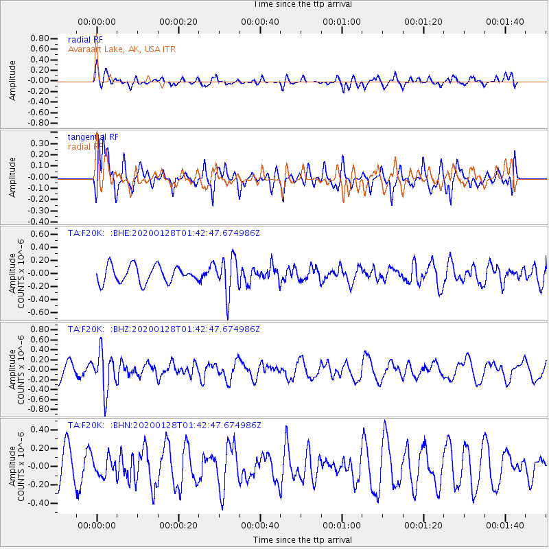
F20K Avaraart Lake, AK, USA - Earthquake Result Viewer
*The percent match for this event was below the threshold and hence no stack was calculated.
| Earthquake location: |
Hokkaido, Japan Region |
| Earthquake latitude/longitude: |
43.6/145.9 |
| Earthquake time(UTC): |
2020/01/28 (028) 01:36:02 GMT |
| Earthquake Depth: |
79 km |
| Earthquake Magnitude: |
5.5 mb |
| Earthquake Catalog/Contributor: |
NEIC PDE/us |
|
| Network: |
TA USArray Transportable Network (new EarthScope stations) |
| Station: |
F20K Avaraart Lake, AK, USA |
| Lat/Lon: |
67.05 N/155.73 W |
| Elevation: |
136 m |
|
| Distance: |
38.6 deg |
| Az: |
32.33 deg |
| Baz: |
262.463 deg |
| Ray Param: |
$rayparam |
*The percent match for this event was below the threshold and hence was not used in the summary stack. |
|
| Radial Match: |
67.9794 % |
| Radial Bump: |
400 |
| Transverse Match: |
76.66721 % |
| Transverse Bump: |
400 |
| SOD ConfigId: |
20465011 |
| Insert Time: |
2020-02-11 01:51:45.146 +0000 |
| GWidth: |
2.5 |
| Max Bumps: |
400 |
| Tol: |
0.001 |
|
Signal To Noise
| Channel | StoN | STA | LTA |
| TA:F20K: :BHZ:20200128T01:42:47.674986Z | 2.3461633 | 3.9859668E-7 | 1.6989299E-7 |
| TA:F20K: :BHN:20200128T01:42:47.674986Z | 0.4436794 | 9.528959E-8 | 2.1477128E-7 |
| TA:F20K: :BHE:20200128T01:42:47.674986Z | 2.1968665 | 2.8396465E-7 | 1.2925894E-7 |
| Arrivals |
| Ps | |
| PpPs | |
| PsPs/PpSs | |


