You are here: Home > Network List > TA - USArray Transportable Network (new EarthScope stations) Stations List
> Station G31M Satah River, YT, CAN > Earthquake Result Viewer
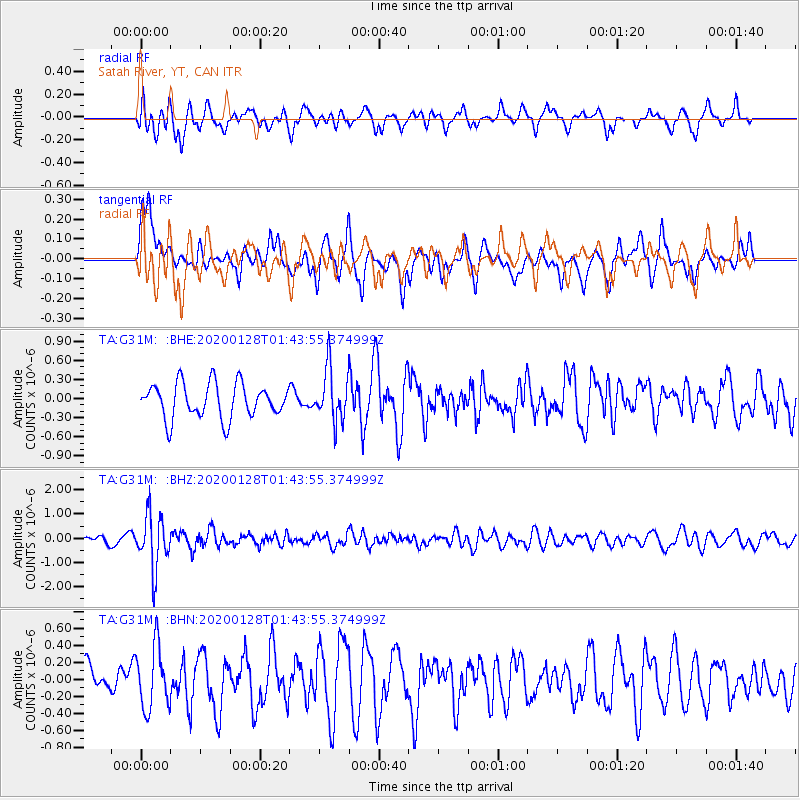
G31M Satah River, YT, CAN - Earthquake Result Viewer
*The percent match for this event was below the threshold and hence no stack was calculated.
| Earthquake location: |
Hokkaido, Japan Region |
| Earthquake latitude/longitude: |
43.6/145.9 |
| Earthquake time(UTC): |
2020/01/28 (028) 01:36:02 GMT |
| Earthquake Depth: |
79 km |
| Earthquake Magnitude: |
5.5 mb |
| Earthquake Catalog/Contributor: |
NEIC PDE/us |
|
| Network: |
TA USArray Transportable Network (new EarthScope stations) |
| Station: |
G31M Satah River, YT, CAN |
| Lat/Lon: |
66.92 N/134.27 W |
| Elevation: |
61 m |
|
| Distance: |
47.0 deg |
| Az: |
32.032 deg |
| Baz: |
282.006 deg |
| Ray Param: |
$rayparam |
*The percent match for this event was below the threshold and hence was not used in the summary stack. |
|
| Radial Match: |
64.59304 % |
| Radial Bump: |
400 |
| Transverse Match: |
43.00893 % |
| Transverse Bump: |
394 |
| SOD ConfigId: |
20465011 |
| Insert Time: |
2020-02-11 01:52:06.880 +0000 |
| GWidth: |
2.5 |
| Max Bumps: |
400 |
| Tol: |
0.001 |
|
Signal To Noise
| Channel | StoN | STA | LTA |
| TA:G31M: :BHZ:20200128T01:43:55.374999Z | 5.073239 | 1.1107732E-6 | 2.1894753E-7 |
| TA:G31M: :BHN:20200128T01:43:55.374999Z | 1.440606 | 3.70189E-7 | 2.5696755E-7 |
| TA:G31M: :BHE:20200128T01:43:55.374999Z | 1.5266336 | 4.143601E-7 | 2.714208E-7 |
| Arrivals |
| Ps | |
| PpPs | |
| PsPs/PpSs | |


