You are here: Home > Network List > US - United States National Seismic Network Stations List
> Station WMOK Wichita Mountains, Oklahoma, USA > Earthquake Result Viewer
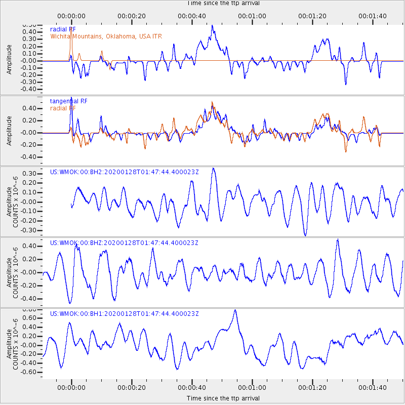
WMOK Wichita Mountains, Oklahoma, USA - Earthquake Result Viewer
*The percent match for this event was below the threshold and hence no stack was calculated.
| Earthquake location: |
Hokkaido, Japan Region |
| Earthquake latitude/longitude: |
43.6/145.9 |
| Earthquake time(UTC): |
2020/01/28 (028) 01:36:02 GMT |
| Earthquake Depth: |
79 km |
| Earthquake Magnitude: |
5.5 mb |
| Earthquake Catalog/Contributor: |
NEIC PDE/us |
|
| Network: |
US United States National Seismic Network |
| Station: |
WMOK Wichita Mountains, Oklahoma, USA |
| Lat/Lon: |
34.74 N/98.78 W |
| Elevation: |
486 m |
|
| Distance: |
82.3 deg |
| Az: |
48.721 deg |
| Baz: |
318.441 deg |
| Ray Param: |
$rayparam |
*The percent match for this event was below the threshold and hence was not used in the summary stack. |
|
| Radial Match: |
35.502483 % |
| Radial Bump: |
400 |
| Transverse Match: |
30.995619 % |
| Transverse Bump: |
400 |
| SOD ConfigId: |
20465011 |
| Insert Time: |
2020-02-11 01:54:30.662 +0000 |
| GWidth: |
2.5 |
| Max Bumps: |
400 |
| Tol: |
0.001 |
|
Signal To Noise
| Channel | StoN | STA | LTA |
| US:WMOK:00:BHZ:20200128T01:47:44.400023Z | 2.1056805 | 3.0633075E-7 | 1.4547827E-7 |
| US:WMOK:00:BH1:20200128T01:47:44.400023Z | 2.5515049 | 3.8126072E-7 | 1.4942583E-7 |
| US:WMOK:00:BH2:20200128T01:47:44.400023Z | 1.0899953 | 8.65522E-8 | 7.9406036E-8 |
| Arrivals |
| Ps | |
| PpPs | |
| PsPs/PpSs | |


