You are here: Home > Network List > IW - Intermountain West Stations List
> Station DLMT Dillon, Montana, USA > Earthquake Result Viewer
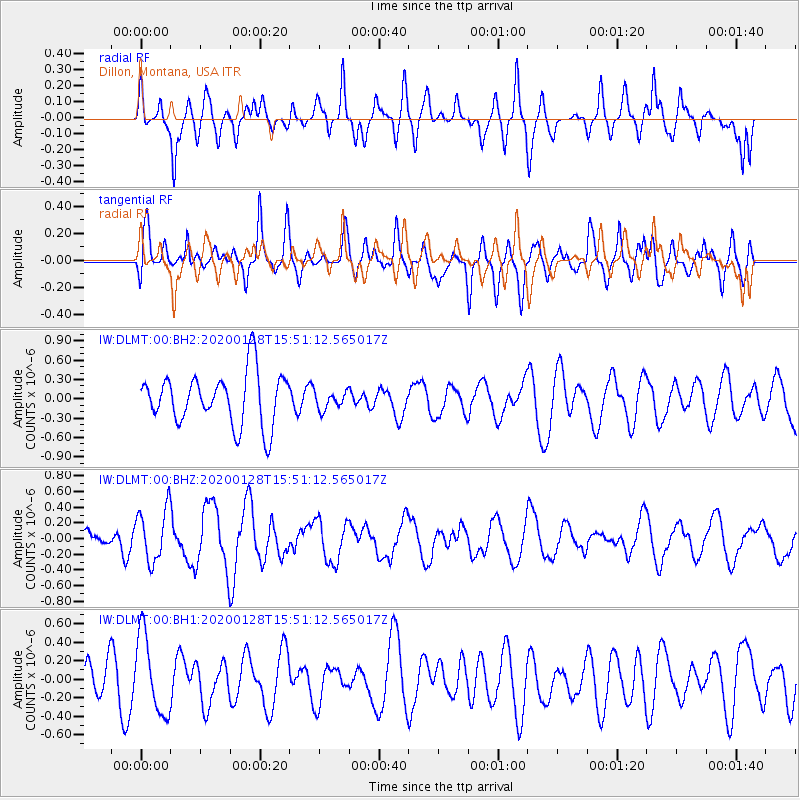
DLMT Dillon, Montana, USA - Earthquake Result Viewer
*The percent match for this event was below the threshold and hence no stack was calculated.
| Earthquake location: |
Dodecanese Islands, Greece |
| Earthquake latitude/longitude: |
35.2/27.9 |
| Earthquake time(UTC): |
2020/01/28 (028) 15:38:34 GMT |
| Earthquake Depth: |
10 km |
| Earthquake Magnitude: |
5.4 Mww |
| Earthquake Catalog/Contributor: |
NEIC PDE/us |
|
| Network: |
IW Intermountain West |
| Station: |
DLMT Dillon, Montana, USA |
| Lat/Lon: |
45.36 N/112.60 W |
| Elevation: |
1569 m |
|
| Distance: |
92.2 deg |
| Az: |
333.332 deg |
| Baz: |
31.421 deg |
| Ray Param: |
$rayparam |
*The percent match for this event was below the threshold and hence was not used in the summary stack. |
|
| Radial Match: |
61.889935 % |
| Radial Bump: |
400 |
| Transverse Match: |
54.833267 % |
| Transverse Bump: |
400 |
| SOD ConfigId: |
20465011 |
| Insert Time: |
2020-02-11 15:44:31.382 +0000 |
| GWidth: |
2.5 |
| Max Bumps: |
400 |
| Tol: |
0.001 |
|
Signal To Noise
| Channel | StoN | STA | LTA |
| IW:DLMT:00:BHZ:20200128T15:51:12.565017Z | 2.8102748 | 3.3864177E-7 | 1.205013E-7 |
| IW:DLMT:00:BH1:20200128T15:51:12.565017Z | 1.455604 | 4.2938285E-7 | 2.9498602E-7 |
| IW:DLMT:00:BH2:20200128T15:51:12.565017Z | 0.34258944 | 1.3840433E-7 | 4.0399473E-7 |
| Arrivals |
| Ps | |
| PpPs | |
| PsPs/PpSs | |


