You are here: Home > Network List > US - United States National Seismic Network Stations List
> Station DGMT Dagmar, Montana, USA > Earthquake Result Viewer
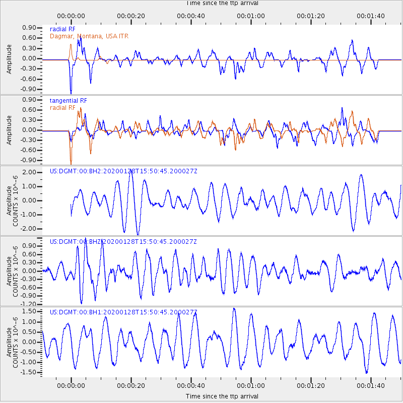
DGMT Dagmar, Montana, USA - Earthquake Result Viewer
*The percent match for this event was below the threshold and hence no stack was calculated.
| Earthquake location: |
Dodecanese Islands, Greece |
| Earthquake latitude/longitude: |
35.2/27.9 |
| Earthquake time(UTC): |
2020/01/28 (028) 15:38:34 GMT |
| Earthquake Depth: |
10 km |
| Earthquake Magnitude: |
5.4 Mww |
| Earthquake Catalog/Contributor: |
NEIC PDE/us |
|
| Network: |
US United States National Seismic Network |
| Station: |
DGMT Dagmar, Montana, USA |
| Lat/Lon: |
48.47 N/104.20 W |
| Elevation: |
0.0 m |
|
| Distance: |
86.4 deg |
| Az: |
330.342 deg |
| Baz: |
37.508 deg |
| Ray Param: |
$rayparam |
*The percent match for this event was below the threshold and hence was not used in the summary stack. |
|
| Radial Match: |
55.452984 % |
| Radial Bump: |
382 |
| Transverse Match: |
44.488888 % |
| Transverse Bump: |
275 |
| SOD ConfigId: |
20465011 |
| Insert Time: |
2020-02-11 15:51:56.892 +0000 |
| GWidth: |
2.5 |
| Max Bumps: |
400 |
| Tol: |
0.001 |
|
Signal To Noise
| Channel | StoN | STA | LTA |
| US:DGMT:00:BHZ:20200128T15:50:45.200027Z | 2.542779 | 6.0197794E-7 | 2.3674019E-7 |
| US:DGMT:00:BH1:20200128T15:50:45.200027Z | 0.8517623 | 7.5077327E-7 | 8.8143514E-7 |
| US:DGMT:00:BH2:20200128T15:50:45.200027Z | 0.40663117 | 4.194832E-7 | 1.0316061E-6 |
| Arrivals |
| Ps | |
| PpPs | |
| PsPs/PpSs | |


