You are here: Home > Network List > US - United States National Seismic Network Stations List
> Station HAWA Hanford, Washington, USA > Earthquake Result Viewer
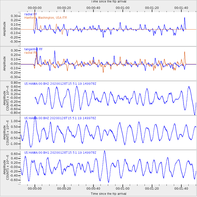
HAWA Hanford, Washington, USA - Earthquake Result Viewer
*The percent match for this event was below the threshold and hence no stack was calculated.
| Earthquake location: |
Dodecanese Islands, Greece |
| Earthquake latitude/longitude: |
35.2/27.9 |
| Earthquake time(UTC): |
2020/01/28 (028) 15:38:34 GMT |
| Earthquake Depth: |
10 km |
| Earthquake Magnitude: |
5.4 Mww |
| Earthquake Catalog/Contributor: |
NEIC PDE/us |
|
| Network: |
US United States National Seismic Network |
| Station: |
HAWA Hanford, Washington, USA |
| Lat/Lon: |
46.39 N/119.53 W |
| Elevation: |
364 m |
|
| Distance: |
93.6 deg |
| Az: |
338.078 deg |
| Baz: |
26.213 deg |
| Ray Param: |
$rayparam |
*The percent match for this event was below the threshold and hence was not used in the summary stack. |
|
| Radial Match: |
48.38083 % |
| Radial Bump: |
400 |
| Transverse Match: |
69.86789 % |
| Transverse Bump: |
369 |
| SOD ConfigId: |
20465011 |
| Insert Time: |
2020-02-11 15:52:02.619 +0000 |
| GWidth: |
2.5 |
| Max Bumps: |
400 |
| Tol: |
0.001 |
|
Signal To Noise
| Channel | StoN | STA | LTA |
| US:HAWA:00:BHZ:20200128T15:51:19.149978Z | 2.018298 | 7.3585005E-7 | 3.6458943E-7 |
| US:HAWA:00:BH1:20200128T15:51:19.149978Z | 0.808598 | 2.1158799E-7 | 2.6167265E-7 |
| US:HAWA:00:BH2:20200128T15:51:19.149978Z | 1.1915386 | 3.7396865E-7 | 3.1385358E-7 |
| Arrivals |
| Ps | |
| PpPs | |
| PsPs/PpSs | |


