You are here: Home > Network List > TS - TERRAscope (Southern California Seismic Network) Stations List
> Station PFO Pinon Flat, California, USA > Earthquake Result Viewer
PFO Pinon Flat, California, USA - Earthquake Result Viewer

| Earthquake location: |
Kuril Islands |
| Earthquake latitude/longitude: |
45.6/151.7 |
| Earthquake time(UTC): |
1991/12/13 (347) 18:59:11 GMT |
| Earthquake Depth: |
52 km |
| Earthquake Magnitude: |
6.2 MB |
| Earthquake Catalog/Contributor: |
WHDF/NEIC |
|
| Network: |
TS TERRAscope (Southern California Seismic Network) |
| Station: |
PFO Pinon Flat, California, USA |
| Lat/Lon: |
33.61 N/116.46 W |
| Elevation: |
1280 m |
|
| Distance: |
68.1 deg |
| Az: |
64.044 deg |
| Baz: |
310.799 deg |
| Ray Param: |
0.056431778 |
| Estimated Moho Depth: |
30.5 km |
| Estimated Crust Vp/Vs: |
1.70 |
| Assumed Crust Vp: |
6.264 km/s |
| Estimated Crust Vs: |
3.684 km/s |
| Estimated Crust Poisson's Ratio: |
0.24 |
|
| Radial Match: |
85.89004 % |
| Radial Bump: |
337 |
| Transverse Match: |
56.025497 % |
| Transverse Bump: |
295 |
| SOD ConfigId: |
16938 |
| Insert Time: |
2010-02-26 14:41:32.293 +0000 |
| GWidth: |
2.5 |
| Max Bumps: |
400 |
| Tol: |
0.001 |
|
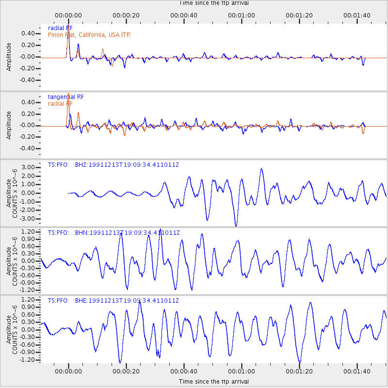
Signal To Noise
| Channel | StoN | STA | LTA |
| TS:PFO: :BHN:19911213T19:09:34.411011Z | 0.6117957 | 1.6746507E-7 | 2.737271E-7 |
| TS:PFO: :BHE:19911213T19:09:34.411011Z | 0.9963877 | 1.5213645E-7 | 1.52688E-7 |
| TS:PFO: :BHZ:19911213T19:09:34.411011Z | 3.093596 | 6.414185E-7 | 2.0733754E-7 |
| Arrivals |
| Ps | 3.5 SECOND |
| PpPs | 13 SECOND |
| PsPs/PpSs | 16 SECOND |


