You are here: Home > Network List > US - United States National Seismic Network Stations List
> Station EGMT Eagleton, Montana, USA > Earthquake Result Viewer
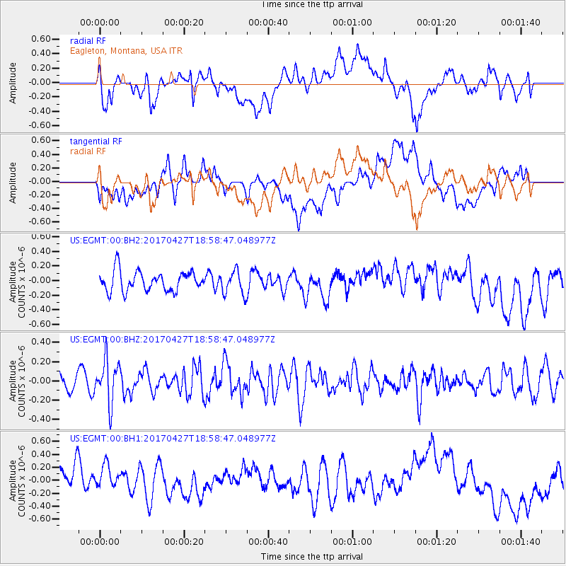
EGMT Eagleton, Montana, USA - Earthquake Result Viewer
*The percent match for this event was below the threshold and hence no stack was calculated.
| Earthquake location: |
Tonga Islands |
| Earthquake latitude/longitude: |
-16.5/-173.7 |
| Earthquake time(UTC): |
2017/04/27 (117) 18:46:42 GMT |
| Earthquake Depth: |
33 km |
| Earthquake Magnitude: |
5.5 mb |
| Earthquake Catalog/Contributor: |
NEIC PDE/us |
|
| Network: |
US United States National Seismic Network |
| Station: |
EGMT Eagleton, Montana, USA |
| Lat/Lon: |
48.02 N/109.75 W |
| Elevation: |
1055 m |
|
| Distance: |
85.8 deg |
| Az: |
37.198 deg |
| Baz: |
239.762 deg |
| Ray Param: |
$rayparam |
*The percent match for this event was below the threshold and hence was not used in the summary stack. |
|
| Radial Match: |
31.58738 % |
| Radial Bump: |
400 |
| Transverse Match: |
35.161938 % |
| Transverse Bump: |
400 |
| SOD ConfigId: |
2028011 |
| Insert Time: |
2017-05-11 18:54:24.020 +0000 |
| GWidth: |
2.5 |
| Max Bumps: |
400 |
| Tol: |
0.001 |
|
Signal To Noise
| Channel | StoN | STA | LTA |
| US:EGMT:00:BHZ:20170427T18:58:47.048977Z | 3.0534563 | 2.2948028E-7 | 7.515427E-8 |
| US:EGMT:00:BH1:20170427T18:58:47.048977Z | 0.97907996 | 2.204466E-7 | 2.251569E-7 |
| US:EGMT:00:BH2:20170427T18:58:47.048977Z | 1.2317387 | 1.6659877E-7 | 1.3525496E-7 |
| Arrivals |
| Ps | |
| PpPs | |
| PsPs/PpSs | |


