You are here: Home > Network List > TS - TERRAscope (Southern California Seismic Network) Stations List
> Station PFO Pinon Flat, California, USA > Earthquake Result Viewer
PFO Pinon Flat, California, USA - Earthquake Result Viewer
| Earthquake location: |
Kuril Islands |
| Earthquake latitude/longitude: |
45.5/151.0 |
| Earthquake time(UTC): |
1991/12/22 (356) 08:43:13 GMT |
| Earthquake Depth: |
26 km |
| Earthquake Magnitude: |
6.3 MB, 7.4 MS |
| Earthquake Catalog/Contributor: |
WHDF/NEIC |
|
| Network: |
TS TERRAscope (Southern California Seismic Network) |
| Station: |
PFO Pinon Flat, California, USA |
| Lat/Lon: |
33.61 N/116.46 W |
| Elevation: |
1280 m |
|
| Distance: |
68.5 deg |
| Az: |
63.622 deg |
| Baz: |
310.946 deg |
| Ray Param: |
0.056205347 |
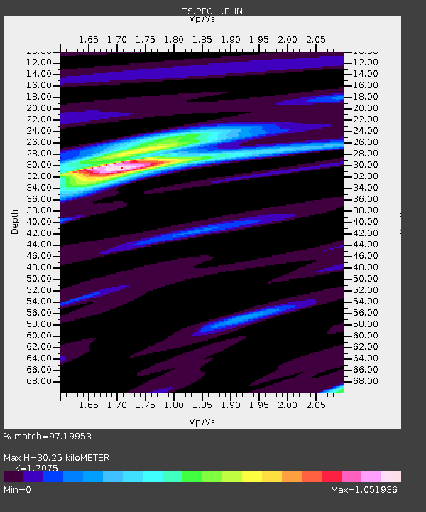
| Estimated Moho Depth: |
30.25 km |
| Estimated Crust Vp/Vs: |
1.71 |
| Assumed Crust Vp: |
6.264 km/s |
| Estimated Crust Vs: |
3.668 km/s |
| Estimated Crust Poisson's Ratio: |
0.24 |
|
| Radial Match: |
97.19953 % |
| Radial Bump: |
254 |
| Transverse Match: |
85.652756 % |
| Transverse Bump: |
400 |
| SOD ConfigId: |
16938 |
| Insert Time: |
2010-02-26 14:41:33.498 +0000 |
| GWidth: |
2.5 |
| Max Bumps: |
400 |
| Tol: |
0.001 |
|

Signal To Noise
| Channel | StoN | STA | LTA |
| TS:PFO: :BHN:19911222T08:53:42.432019Z | 1.96774 | 4.8407094E-7 | 2.460035E-7 |
| TS:PFO: :BHE:19911222T08:53:42.432019Z | 2.101481 | 2.6052228E-7 | 1.239708E-7 |
| TS:PFO: :BHZ:19911222T08:53:42.432019Z | 3.3049421 | 8.5596395E-7 | 2.5899513E-7 |
| Arrivals |
| Ps | 3.5 SECOND |
| PpPs | 13 SECOND |
| PsPs/PpSs | 16 SECOND |


