You are here: Home > Network List > AZ - ANZA Regional Network Stations List
> Station SMER AZ.SMER > Earthquake Result Viewer
SMER AZ.SMER - Earthquake Result Viewer
| Earthquake location: |
Cuba Region |
| Earthquake latitude/longitude: |
19.3/-78.8 |
| Earthquake time(UTC): |
2020/01/28 (028) 19:10:23 GMT |
| Earthquake Depth: |
10 km |
| Earthquake Magnitude: |
7.3 Mi |
| Earthquake Catalog/Contributor: |
NEIC PDE/pt |
|
| Network: |
AZ ANZA Regional Network |
| Station: |
SMER AZ.SMER |
| Lat/Lon: |
33.46 N/117.17 W |
| Elevation: |
355 m |
|
| Distance: |
36.9 deg |
| Az: |
300.263 deg |
| Baz: |
102.648 deg |
| Ray Param: |
0.076446876 |
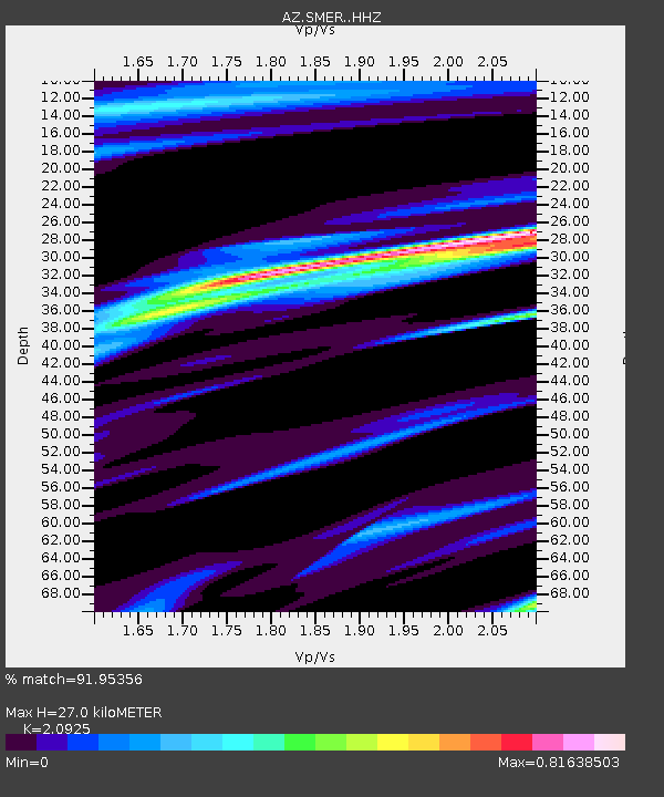
| Estimated Moho Depth: |
27.0 km |
| Estimated Crust Vp/Vs: |
2.09 |
| Assumed Crust Vp: |
6.264 km/s |
| Estimated Crust Vs: |
2.993 km/s |
| Estimated Crust Poisson's Ratio: |
0.35 |
|
| Radial Match: |
91.95356 % |
| Radial Bump: |
243 |
| Transverse Match: |
72.0383 % |
| Transverse Bump: |
340 |
| SOD ConfigId: |
20465011 |
| Insert Time: |
2020-02-11 19:13:09.842 +0000 |
| GWidth: |
2.5 |
| Max Bumps: |
400 |
| Tol: |
0.001 |
|
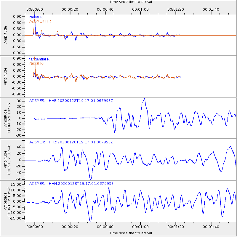
Signal To Noise
| Channel | StoN | STA | LTA |
| AZ:SMER: :HHZ:20200128T19:17:01.067993Z | 2.6313918 | 1.8374865E-6 | 6.982945E-7 |
| AZ:SMER: :HHN:20200128T19:17:01.067993Z | 3.4471395 | 7.271578E-7 | 2.1094526E-7 |
| AZ:SMER: :HHE:20200128T19:17:01.067993Z | 2.1541004 | 1.3880706E-6 | 6.4438524E-7 |
| Arrivals |
| Ps | 5.0 SECOND |
| PpPs | 13 SECOND |
| PsPs/PpSs | 18 SECOND |


