You are here: Home > Network List > C0 - Colorado Geological Survey Seismic Network Stations List
> Station HAYD Hayden Colorado > Earthquake Result Viewer
HAYD Hayden Colorado - Earthquake Result Viewer
| Earthquake location: |
Cuba Region |
| Earthquake latitude/longitude: |
19.3/-78.8 |
| Earthquake time(UTC): |
2020/01/28 (028) 19:10:23 GMT |
| Earthquake Depth: |
10 km |
| Earthquake Magnitude: |
7.3 Mi |
| Earthquake Catalog/Contributor: |
NEIC PDE/pt |
|
| Network: |
C0 Colorado Geological Survey Seismic Network |
| Station: |
HAYD Hayden Colorado |
| Lat/Lon: |
40.53 N/107.27 W |
| Elevation: |
2202 m |
|
| Distance: |
32.2 deg |
| Az: |
317.113 deg |
| Baz: |
122.52 deg |
| Ray Param: |
0.078748405 |
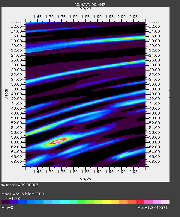
| Estimated Moho Depth: |
59.5 km |
| Estimated Crust Vp/Vs: |
1.73 |
| Assumed Crust Vp: |
6.159 km/s |
| Estimated Crust Vs: |
3.56 km/s |
| Estimated Crust Poisson's Ratio: |
0.25 |
|
| Radial Match: |
89.00805 % |
| Radial Bump: |
338 |
| Transverse Match: |
57.233395 % |
| Transverse Bump: |
400 |
| SOD ConfigId: |
20465011 |
| Insert Time: |
2020-02-11 19:13:49.814 +0000 |
| GWidth: |
2.5 |
| Max Bumps: |
400 |
| Tol: |
0.001 |
|

Signal To Noise
| Channel | StoN | STA | LTA |
| C0:HAYD:00:HHZ:20200128T19:16:20.820007Z | 2.702048 | 4.321955E-7 | 1.5995109E-7 |
| C0:HAYD:00:HHN:20200128T19:16:20.820007Z | 1.8035529 | 2.6767103E-7 | 1.4841318E-7 |
| C0:HAYD:00:HHE:20200128T19:16:20.820007Z | 1.8929126 | 3.1468733E-7 | 1.6624503E-7 |
| Arrivals |
| Ps | 7.6 SECOND |
| PpPs | 24 SECOND |
| PsPs/PpSs | 32 SECOND |


