You are here: Home > Network List > CI - Caltech Regional Seismic Network Stations List
> Station LRL Laurel Mtn Radio Fac, Ridgecrest, CA, USA > Earthquake Result Viewer
LRL Laurel Mtn Radio Fac, Ridgecrest, CA, USA - Earthquake Result Viewer
| Earthquake location: |
Cuba Region |
| Earthquake latitude/longitude: |
19.3/-78.8 |
| Earthquake time(UTC): |
2020/01/28 (028) 19:10:23 GMT |
| Earthquake Depth: |
10 km |
| Earthquake Magnitude: |
7.3 Mi |
| Earthquake Catalog/Contributor: |
NEIC PDE/pt |
|
| Network: |
CI Caltech Regional Seismic Network |
| Station: |
LRL Laurel Mtn Radio Fac, Ridgecrest, CA, USA |
| Lat/Lon: |
35.48 N/117.68 W |
| Elevation: |
1340 m |
|
| Distance: |
37.8 deg |
| Az: |
303.327 deg |
| Baz: |
104.796 deg |
| Ray Param: |
0.075932264 |
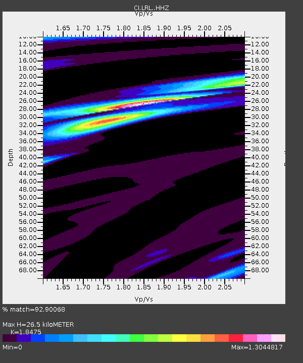
| Estimated Moho Depth: |
26.5 km |
| Estimated Crust Vp/Vs: |
1.85 |
| Assumed Crust Vp: |
6.276 km/s |
| Estimated Crust Vs: |
3.397 km/s |
| Estimated Crust Poisson's Ratio: |
0.29 |
|
| Radial Match: |
92.90068 % |
| Radial Bump: |
239 |
| Transverse Match: |
70.623184 % |
| Transverse Bump: |
397 |
| SOD ConfigId: |
20465011 |
| Insert Time: |
2020-02-11 19:15:47.715 +0000 |
| GWidth: |
2.5 |
| Max Bumps: |
400 |
| Tol: |
0.001 |
|

Signal To Noise
| Channel | StoN | STA | LTA |
| CI:LRL: :HHZ:20200128T19:17:08.588013Z | 2.2763646 | 1.7513056E-6 | 7.6934316E-7 |
| CI:LRL: :HHN:20200128T19:17:08.588013Z | 1.4095076 | 6.1460366E-7 | 4.3604138E-7 |
| CI:LRL: :HHE:20200128T19:17:08.588013Z | 2.0449479 | 1.4586451E-6 | 7.132921E-7 |
| Arrivals |
| Ps | 3.8 SECOND |
| PpPs | 11 SECOND |
| PsPs/PpSs | 15 SECOND |


