You are here: Home > Network List > TS - TERRAscope (Southern California Seismic Network) Stations List
> Station PFO Pinon Flat, California, USA > Earthquake Result Viewer
PFO Pinon Flat, California, USA - Earthquake Result Viewer
| Earthquake location: |
Southeast Of Loyalty Islands |
| Earthquake latitude/longitude: |
-21.2/170.0 |
| Earthquake time(UTC): |
1991/01/20 (020) 11:32:53 GMT |
| Earthquake Depth: |
88 km |
| Earthquake Magnitude: |
5.8 MB |
| Earthquake Catalog/Contributor: |
WHDF/NEIC |
|
| Network: |
TS TERRAscope (Southern California Seismic Network) |
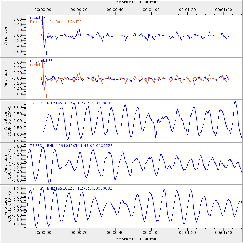
| Station: |
PFO Pinon Flat, California, USA |
| Lat/Lon: |
33.61 N/116.46 W |
| Elevation: |
1280 m |
|
| Distance: |
88.8 deg |
| Az: |
53.194 deg |
| Baz: |
243.509 deg |
| Ray Param: |
0.042172156 |
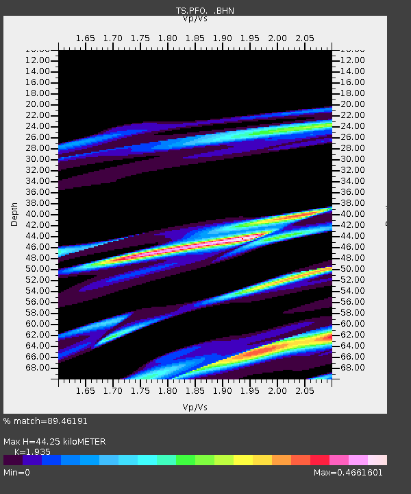
| Estimated Moho Depth: |
44.25 km |
| Estimated Crust Vp/Vs: |
1.93 |
| Assumed Crust Vp: |
6.264 km/s |
| Estimated Crust Vs: |
3.237 km/s |
| Estimated Crust Poisson's Ratio: |
0.32 |
|
| Radial Match: |
89.46191 % |
| Radial Bump: |
400 |
| Transverse Match: |
49.602905 % |
| Transverse Bump: |
400 |
| SOD ConfigId: |
17000 |
| Insert Time: |
2010-02-26 14:41:34.771 +0000 |
| GWidth: |
2.5 |
| Max Bumps: |
400 |
| Tol: |
0.001 |
|
Signal To Noise
| Channel | StoN | STA | LTA |
| TS:PFO: :BHN:19910120T11:45:06.010022Z | 1.6550624 | 6.6277545E-7 | 4.0045342E-7 |
| TS:PFO: :BHE:19910120T11:45:06.008008Z | 1.4670215 | 9.717652E-7 | 6.62407E-7 |
| TS:PFO: :BHZ:19910120T11:45:06.008008Z | 0.9078125 | 6.766701E-7 | 7.453853E-7 |
| Arrivals |
| Ps | 6.7 SECOND |
| PpPs | 20 SECOND |
| PsPs/PpSs | 27 SECOND |


