You are here: Home > Network List > TS - TERRAscope (Southern California Seismic Network) Stations List
> Station PFO Pinon Flat, California, USA > Earthquake Result Viewer
PFO Pinon Flat, California, USA - Earthquake Result Viewer
| Earthquake location: |
Rat Islands, Aleutian Islands |
| Earthquake latitude/longitude: |
52.0/178.9 |
| Earthquake time(UTC): |
1991/01/23 (023) 01:12:30 GMT |
| Earthquake Depth: |
116 km |
| Earthquake Magnitude: |
5.9 MB |
| Earthquake Catalog/Contributor: |
WHDF/NEIC |
|
| Network: |
TS TERRAscope (Southern California Seismic Network) |
| Station: |
PFO Pinon Flat, California, USA |
| Lat/Lon: |
33.61 N/116.46 W |
| Elevation: |
1280 m |
|
| Distance: |
49.2 deg |
| Az: |
85.455 deg |
| Baz: |
312.422 deg |
| Ray Param: |
0.068480104 |
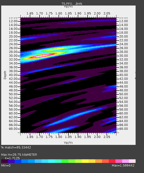
| Estimated Moho Depth: |
29.75 km |
| Estimated Crust Vp/Vs: |
1.71 |
| Assumed Crust Vp: |
6.264 km/s |
| Estimated Crust Vs: |
3.658 km/s |
| Estimated Crust Poisson's Ratio: |
0.24 |
|
| Radial Match: |
95.33442 % |
| Radial Bump: |
217 |
| Transverse Match: |
68.41947 % |
| Transverse Bump: |
400 |
| SOD ConfigId: |
17000 |
| Insert Time: |
2010-02-26 14:41:36.442 +0000 |
| GWidth: |
2.5 |
| Max Bumps: |
400 |
| Tol: |
0.001 |
|
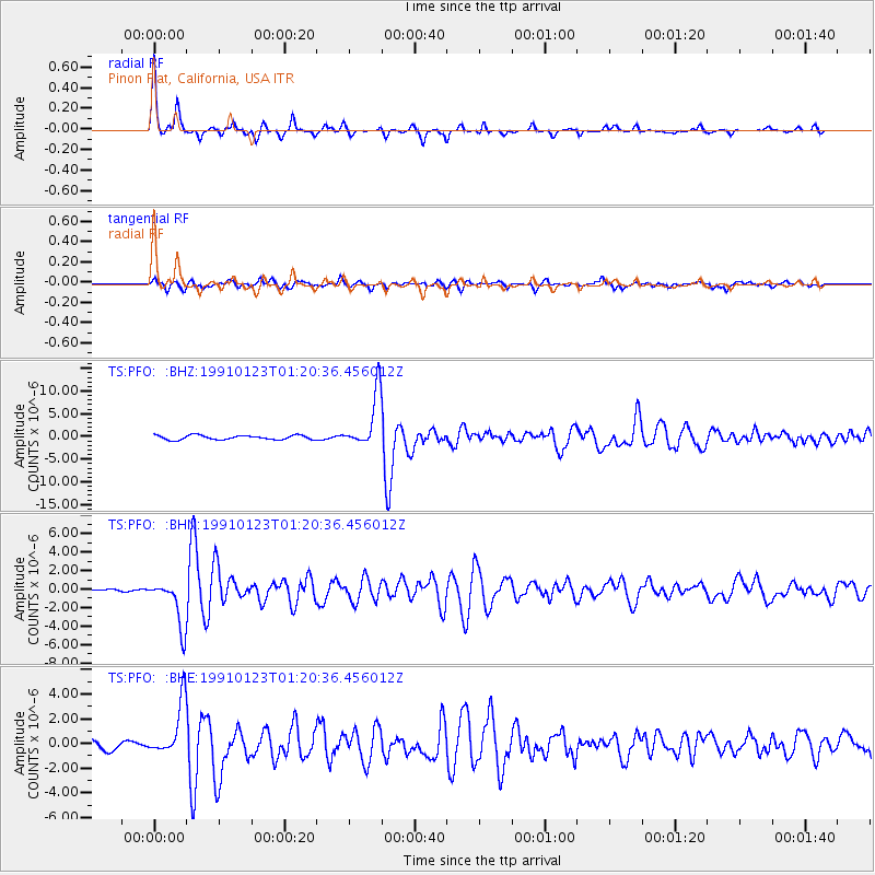
Signal To Noise
| Channel | StoN | STA | LTA |
| TS:PFO: :BHN:19910123T01:20:36.456012Z | 12.744529 | 2.5449506E-6 | 1.9968967E-7 |
| TS:PFO: :BHE:19910123T01:20:36.456012Z | 5.756349 | 2.199031E-6 | 3.8201838E-7 |
| TS:PFO: :BHZ:19910123T01:20:36.456012Z | 12.773504 | 6.0839675E-6 | 4.762959E-7 |
| Arrivals |
| Ps | 3.6 SECOND |
| PpPs | 12 SECOND |
| PsPs/PpSs | 16 SECOND |


