You are here: Home > Network List > IU - Global Seismograph Network (GSN - IRIS/USGS) Stations List
> Station RSSD Black Hills, South Dakota, USA > Earthquake Result Viewer
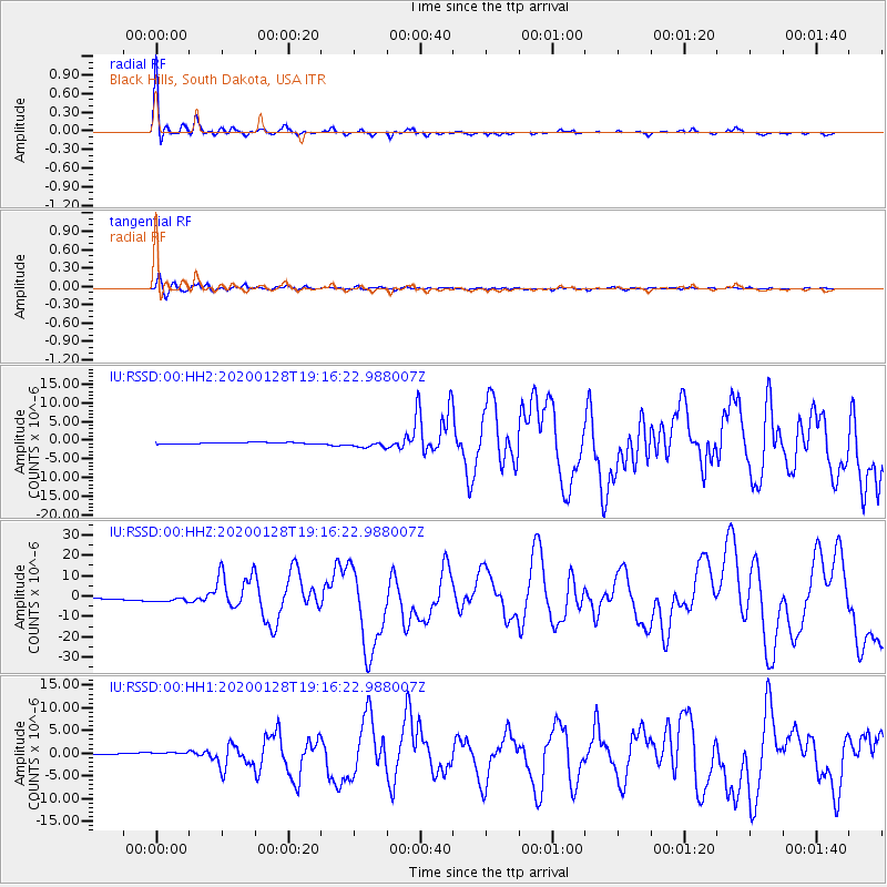
RSSD Black Hills, South Dakota, USA - Earthquake Result Viewer
| Earthquake location: |
Cuba Region |
| Earthquake latitude/longitude: |
19.3/-78.8 |
| Earthquake time(UTC): |
2020/01/28 (028) 19:10:23 GMT |
| Earthquake Depth: |
10 km |
| Earthquake Magnitude: |
7.3 Mi |
| Earthquake Catalog/Contributor: |
NEIC PDE/pt |
|
| Network: |
IU Global Seismograph Network (GSN - IRIS/USGS) |
| Station: |
RSSD Black Hills, South Dakota, USA |
| Lat/Lon: |
44.12 N/104.04 W |
| Elevation: |
2090 m |
|
| Distance: |
32.5 deg |
| Az: |
325.164 deg |
| Baz: |
131.492 deg |
| Ray Param: |
0.078639455 |
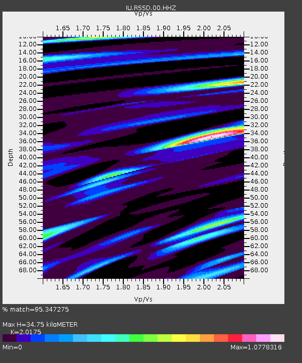
| Estimated Moho Depth: |
34.75 km |
| Estimated Crust Vp/Vs: |
2.02 |
| Assumed Crust Vp: |
6.242 km/s |
| Estimated Crust Vs: |
3.094 km/s |
| Estimated Crust Poisson's Ratio: |
0.34 |
|
| Radial Match: |
95.347275 % |
| Radial Bump: |
312 |
| Transverse Match: |
87.51189 % |
| Transverse Bump: |
400 |
| SOD ConfigId: |
20465011 |
| Insert Time: |
2020-02-11 19:18:59.008 +0000 |
| GWidth: |
2.5 |
| Max Bumps: |
400 |
| Tol: |
0.001 |
|
Signal To Noise
| Channel | StoN | STA | LTA |
| IU:RSSD:00:HHZ:20200128T19:16:22.988007Z | 5.195884 | 1.2181526E-6 | 2.3444568E-7 |
| IU:RSSD:00:HH1:20200128T19:16:22.988007Z | 3.5917046 | 3.4076655E-7 | 9.487599E-8 |
| IU:RSSD:00:HH2:20200128T19:16:22.988007Z | 4.0809736 | 8.81912E-7 | 2.1610333E-7 |
| Arrivals |
| Ps | 6.0 SECOND |
| PpPs | 16 SECOND |
| PsPs/PpSs | 22 SECOND |


