You are here: Home > Network List > MN - MEDNET Project Stations List
> Station VSL Villasalto, Italy > Earthquake Result Viewer
VSL Villasalto, Italy - Earthquake Result Viewer

| Earthquake location: |
Peru-Brazil Border Region |
| Earthquake latitude/longitude: |
-11.0/-70.8 |
| Earthquake time(UTC): |
1990/10/17 (290) 14:30:14 GMT |
| Earthquake Depth: |
624 km |
| Earthquake Magnitude: |
6.7 MB, 6.8 UNKNOWN |
| Earthquake Catalog/Contributor: |
WHDF/NEIC |
|
| Network: |
MN MEDNET Project |
| Station: |
VSL Villasalto, Italy |
| Lat/Lon: |
39.50 N/9.38 E |
| Elevation: |
370 m |
|
| Distance: |
89.4 deg |
| Az: |
49.677 deg |
| Baz: |
255.351 deg |
| Ray Param: |
0.041542407 |
| Estimated Moho Depth: |
28.0 km |
| Estimated Crust Vp/Vs: |
2.10 |
| Assumed Crust Vp: |
6.183 km/s |
| Estimated Crust Vs: |
2.948 km/s |
| Estimated Crust Poisson's Ratio: |
0.35 |
|
| Radial Match: |
93.86464 % |
| Radial Bump: |
400 |
| Transverse Match: |
88.5129 % |
| Transverse Bump: |
400 |
| SOD ConfigId: |
16938 |
| Insert Time: |
2010-03-08 17:43:39.534 +0000 |
| GWidth: |
2.5 |
| Max Bumps: |
400 |
| Tol: |
0.001 |
|
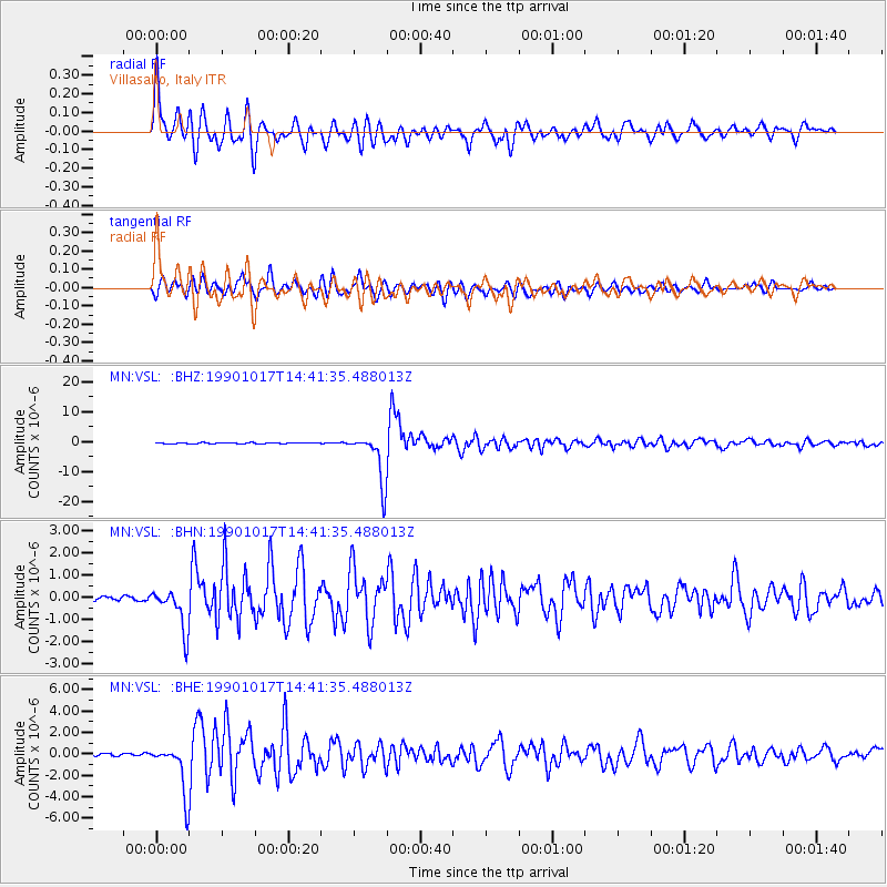
Signal To Noise
| Channel | StoN | STA | LTA |
| MN:VSL: :BHN:19901017T14:41:35.488013Z | 7.668368 | 9.55487E-7 | 1.246011E-7 |
| MN:VSL: :BHE:19901017T14:41:35.488013Z | 14.344313 | 2.2806212E-6 | 1.5899131E-7 |
| MN:VSL: :BHZ:19901017T14:41:35.488013Z | 45.94188 | 8.238034E-6 | 1.7931426E-7 |
| Arrivals |
| Ps | 5.1 SECOND |
| PpPs | 14 SECOND |
| PsPs/PpSs | 19 SECOND |


