You are here: Home > Network List > TA - USArray Transportable Network (new EarthScope stations) Stations List
> Station A21K Barrow, AK, USA > Earthquake Result Viewer
A21K Barrow, AK, USA - Earthquake Result Viewer
| Earthquake location: |
Cuba Region |
| Earthquake latitude/longitude: |
19.3/-78.8 |
| Earthquake time(UTC): |
2020/01/28 (028) 19:10:23 GMT |
| Earthquake Depth: |
10 km |
| Earthquake Magnitude: |
7.3 Mi |
| Earthquake Catalog/Contributor: |
NEIC PDE/pt |
|
| Network: |
TA USArray Transportable Network (new EarthScope stations) |
| Station: |
A21K Barrow, AK, USA |
| Lat/Lon: |
71.32 N/156.62 W |
| Elevation: |
577 m |
|
| Distance: |
67.9 deg |
| Az: |
340.137 deg |
| Baz: |
95.135 deg |
| Ray Param: |
0.05663323 |
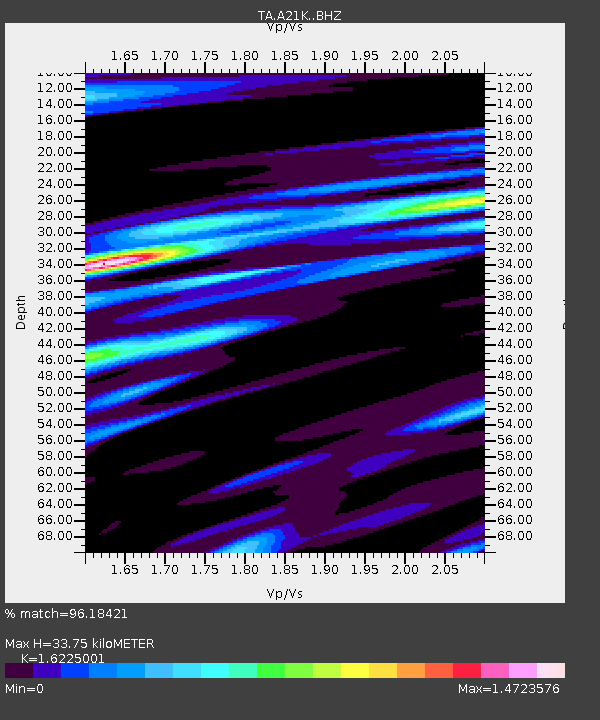
| Estimated Moho Depth: |
33.75 km |
| Estimated Crust Vp/Vs: |
1.62 |
| Assumed Crust Vp: |
6.048 km/s |
| Estimated Crust Vs: |
3.728 km/s |
| Estimated Crust Poisson's Ratio: |
0.19 |
|
| Radial Match: |
96.18421 % |
| Radial Bump: |
393 |
| Transverse Match: |
92.56142 % |
| Transverse Bump: |
400 |
| SOD ConfigId: |
20465011 |
| Insert Time: |
2020-02-11 19:21:37.554 +0000 |
| GWidth: |
2.5 |
| Max Bumps: |
400 |
| Tol: |
0.001 |
|
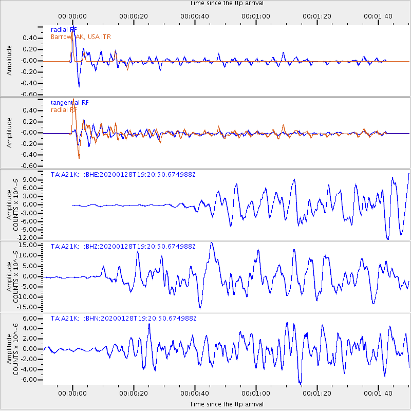
Signal To Noise
| Channel | StoN | STA | LTA |
| TA:A21K: :BHZ:20200128T19:20:50.674988Z | 0.8573116 | 1.7498486E-7 | 2.0410882E-7 |
| TA:A21K: :BHN:20200128T19:20:50.674988Z | 0.66519046 | 1.8437922E-7 | 2.771826E-7 |
| TA:A21K: :BHE:20200128T19:20:50.674988Z | 2.0917387 | 3.6415264E-7 | 1.740909E-7 |
| Arrivals |
| Ps | 3.6 SECOND |
| PpPs | 14 SECOND |
| PsPs/PpSs | 18 SECOND |


