You are here: Home > Network List > TA - USArray Transportable Network (new EarthScope stations) Stations List
> Station L16K Owhat River, AK, USA > Earthquake Result Viewer
L16K Owhat River, AK, USA - Earthquake Result Viewer
| Earthquake location: |
Cuba Region |
| Earthquake latitude/longitude: |
19.3/-78.8 |
| Earthquake time(UTC): |
2020/01/28 (028) 19:10:23 GMT |
| Earthquake Depth: |
10 km |
| Earthquake Magnitude: |
7.3 Mi |
| Earthquake Catalog/Contributor: |
NEIC PDE/pt |
|
| Network: |
TA USArray Transportable Network (new EarthScope stations) |
| Station: |
L16K Owhat River, AK, USA |
| Lat/Lon: |
61.71 N/159.47 W |
| Elevation: |
227 m |
|
| Distance: |
68.8 deg |
| Az: |
329.715 deg |
| Baz: |
88.655 deg |
| Ray Param: |
0.056092635 |
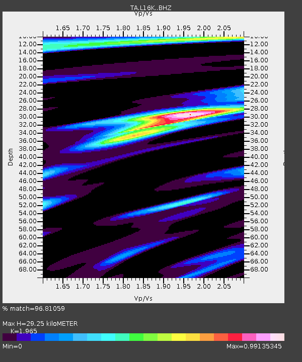
| Estimated Moho Depth: |
29.25 km |
| Estimated Crust Vp/Vs: |
1.97 |
| Assumed Crust Vp: |
6.276 km/s |
| Estimated Crust Vs: |
3.194 km/s |
| Estimated Crust Poisson's Ratio: |
0.33 |
|
| Radial Match: |
96.81059 % |
| Radial Bump: |
400 |
| Transverse Match: |
82.868004 % |
| Transverse Bump: |
400 |
| SOD ConfigId: |
20465011 |
| Insert Time: |
2020-02-11 19:22:32.869 +0000 |
| GWidth: |
2.5 |
| Max Bumps: |
400 |
| Tol: |
0.001 |
|

Signal To Noise
| Channel | StoN | STA | LTA |
| TA:L16K: :BHZ:20200128T19:20:55.849976Z | 2.3697639 | 4.5491103E-7 | 1.9196472E-7 |
| TA:L16K: :BHN:20200128T19:20:55.849976Z | 1.3020512 | 3.4180536E-7 | 2.62513E-7 |
| TA:L16K: :BHE:20200128T19:20:55.849976Z | 0.6173309 | 2.5435935E-7 | 4.120308E-7 |
| Arrivals |
| Ps | 4.6 SECOND |
| PpPs | 13 SECOND |
| PsPs/PpSs | 18 SECOND |


