You are here: Home > Network List > US - United States National Seismic Network Stations List
> Station DGMT Dagmar, Montana, USA > Earthquake Result Viewer
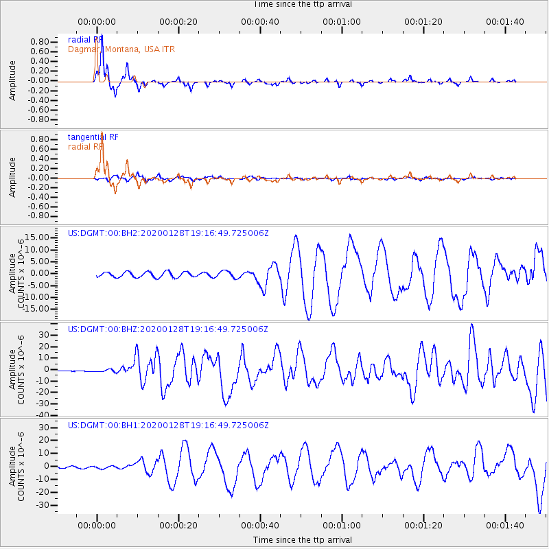
DGMT Dagmar, Montana, USA - Earthquake Result Viewer
*The percent match for this event was below the threshold and hence no stack was calculated.
| Earthquake location: |
Cuba Region |
| Earthquake latitude/longitude: |
19.3/-78.8 |
| Earthquake time(UTC): |
2020/01/28 (028) 19:10:23 GMT |
| Earthquake Depth: |
10 km |
| Earthquake Magnitude: |
7.3 Mi |
| Earthquake Catalog/Contributor: |
NEIC PDE/pt |
|
| Network: |
US United States National Seismic Network |
| Station: |
DGMT Dagmar, Montana, USA |
| Lat/Lon: |
48.47 N/104.20 W |
| Elevation: |
0.0 m |
|
| Distance: |
35.6 deg |
| Az: |
330.646 deg |
| Baz: |
135.922 deg |
| Ray Param: |
$rayparam |
*The percent match for this event was below the threshold and hence was not used in the summary stack. |
|
| Radial Match: |
95.53441 % |
| Radial Bump: |
216 |
| Transverse Match: |
71.8664 % |
| Transverse Bump: |
400 |
| SOD ConfigId: |
20465011 |
| Insert Time: |
2020-02-11 19:23:31.097 +0000 |
| GWidth: |
2.5 |
| Max Bumps: |
400 |
| Tol: |
0.001 |
|
Signal To Noise
| Channel | StoN | STA | LTA |
| US:DGMT:00:BHZ:20200128T19:16:49.725006Z | 3.7185247 | 1.057771E-6 | 2.8445984E-7 |
| US:DGMT:00:BH1:20200128T19:16:49.725006Z | 1.9237192 | 9.820002E-7 | 5.104696E-7 |
| US:DGMT:00:BH2:20200128T19:16:49.725006Z | 1.2763895 | 1.4324146E-6 | 1.1222394E-6 |
| Arrivals |
| Ps | |
| PpPs | |
| PsPs/PpSs | |


