You are here: Home > Network List > US - United States National Seismic Network Stations List
> Station ELK Elko, Nevada, USA > Earthquake Result Viewer
ELK Elko, Nevada, USA - Earthquake Result Viewer
| Earthquake location: |
Cuba Region |
| Earthquake latitude/longitude: |
19.3/-78.8 |
| Earthquake time(UTC): |
2020/01/28 (028) 19:10:23 GMT |
| Earthquake Depth: |
10 km |
| Earthquake Magnitude: |
7.3 Mi |
| Earthquake Catalog/Contributor: |
NEIC PDE/pt |
|
| Network: |
US United States National Seismic Network |
| Station: |
ELK Elko, Nevada, USA |
| Lat/Lon: |
40.74 N/115.24 W |
| Elevation: |
2210 m |
|
| Distance: |
37.7 deg |
| Az: |
312.475 deg |
| Baz: |
113.537 deg |
| Ray Param: |
0.07598795 |
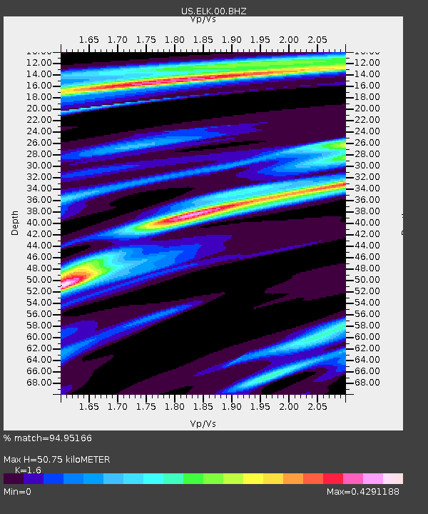
| Estimated Moho Depth: |
50.75 km |
| Estimated Crust Vp/Vs: |
1.60 |
| Assumed Crust Vp: |
6.276 km/s |
| Estimated Crust Vs: |
3.922 km/s |
| Estimated Crust Poisson's Ratio: |
0.18 |
|
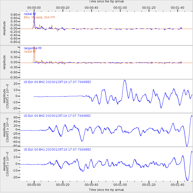
| Radial Match: |
94.95166 % |
| Radial Bump: |
155 |
| Transverse Match: |
49.199833 % |
| Transverse Bump: |
400 |
| SOD ConfigId: |
20465011 |
| Insert Time: |
2020-02-11 19:23:34.471 +0000 |
| GWidth: |
2.5 |
| Max Bumps: |
400 |
| Tol: |
0.001 |
|
Signal To Noise
| Channel | StoN | STA | LTA |
| US:ELK:00:BHZ:20200128T19:17:07.799988Z | 3.1570778 | 1.0888242E-6 | 3.4488355E-7 |
| US:ELK:00:BH1:20200128T19:17:07.799988Z | 1.0168215 | 3.0648917E-7 | 3.0141882E-7 |
| US:ELK:00:BH2:20200128T19:17:07.799988Z | 3.6631508 | 8.554292E-7 | 2.3352278E-7 |
| Arrivals |
| Ps | 5.2 SECOND |
| PpPs | 19 SECOND |
| PsPs/PpSs | 25 SECOND |


