You are here: Home > Network List > UU - University of Utah Regional Network Stations List
> Station BRWY Blue Rim, WY, USA > Earthquake Result Viewer
BRWY Blue Rim, WY, USA - Earthquake Result Viewer
| Earthquake location: |
Cuba Region |
| Earthquake latitude/longitude: |
19.3/-78.8 |
| Earthquake time(UTC): |
2020/01/28 (028) 19:10:23 GMT |
| Earthquake Depth: |
10 km |
| Earthquake Magnitude: |
7.3 Mi |
| Earthquake Catalog/Contributor: |
NEIC PDE/pt |
|
| Network: |
UU University of Utah Regional Network |
| Station: |
BRWY Blue Rim, WY, USA |
| Lat/Lon: |
41.62 N/109.50 W |
| Elevation: |
2098 m |
|
| Distance: |
34.3 deg |
| Az: |
317.18 deg |
| Baz: |
121.112 deg |
| Ray Param: |
0.07783131 |
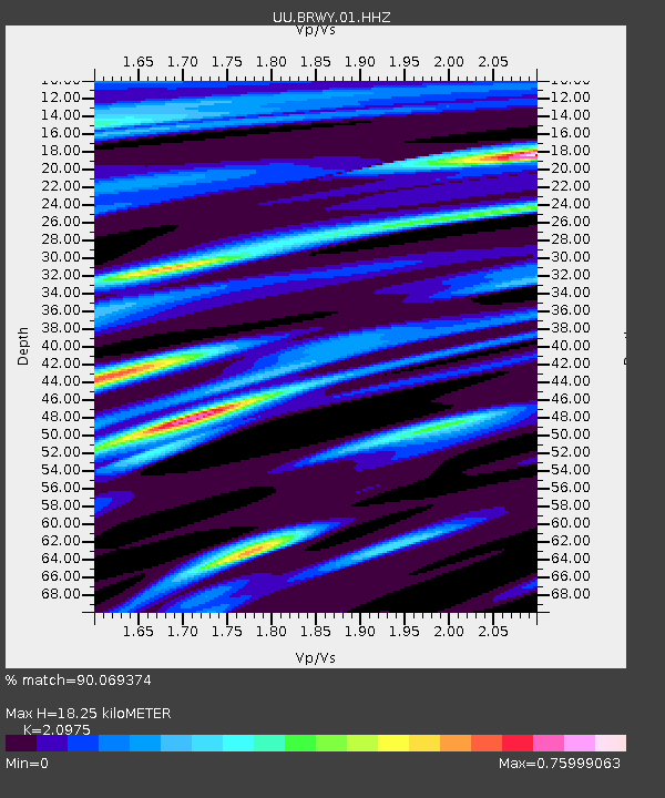
| Estimated Moho Depth: |
18.25 km |
| Estimated Crust Vp/Vs: |
2.10 |
| Assumed Crust Vp: |
6.207 km/s |
| Estimated Crust Vs: |
2.959 km/s |
| Estimated Crust Poisson's Ratio: |
0.35 |
|
| Radial Match: |
90.069374 % |
| Radial Bump: |
400 |
| Transverse Match: |
60.63729 % |
| Transverse Bump: |
400 |
| SOD ConfigId: |
20465011 |
| Insert Time: |
2020-02-11 19:23:56.292 +0000 |
| GWidth: |
2.5 |
| Max Bumps: |
400 |
| Tol: |
0.001 |
|

Signal To Noise
| Channel | StoN | STA | LTA |
| UU:BRWY:01:HHZ:20200128T19:16:38.329987Z | 3.7316892 | 3.4677985E-8 | 9.2928385E-9 |
| UU:BRWY:01:HHN:20200128T19:16:38.329987Z | 1.6302558 | 2.1254255E-8 | 1.3037374E-8 |
| UU:BRWY:01:HHE:20200128T19:16:38.329987Z | 2.212214 | 2.4909415E-8 | 1.12599485E-8 |
| Arrivals |
| Ps | 3.4 SECOND |
| PpPs | 8.6 SECOND |
| PsPs/PpSs | 12 SECOND |


