You are here: Home > Network List > TS - TERRAscope (Southern California Seismic Network) Stations List
> Station PFO Pinon Flat, California, USA > Earthquake Result Viewer
PFO Pinon Flat, California, USA - Earthquake Result Viewer
| Earthquake location: |
Andreanof Islands, Aleutian Is. |
| Earthquake latitude/longitude: |
52.5/-178.9 |
| Earthquake time(UTC): |
1992/03/13 (073) 16:01:06 GMT |
| Earthquake Depth: |
211 km |
| Earthquake Magnitude: |
6.0 MB, 6.3 UNKNOWN |
| Earthquake Catalog/Contributor: |
WHDF/NEIC |
|
| Network: |
TS TERRAscope (Southern California Seismic Network) |
| Station: |
PFO Pinon Flat, California, USA |
| Lat/Lon: |
33.61 N/116.46 W |
| Elevation: |
1280 m |
|
| Distance: |
47.8 deg |
| Az: |
87.535 deg |
| Baz: |
312.928 deg |
| Ray Param: |
0.06896838 |
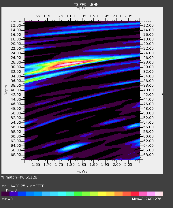
| Estimated Moho Depth: |
28.25 km |
| Estimated Crust Vp/Vs: |
1.80 |
| Assumed Crust Vp: |
6.264 km/s |
| Estimated Crust Vs: |
3.48 km/s |
| Estimated Crust Poisson's Ratio: |
0.28 |
|
| Radial Match: |
90.53128 % |
| Radial Bump: |
395 |
| Transverse Match: |
75.81663 % |
| Transverse Bump: |
400 |
| SOD ConfigId: |
16938 |
| Insert Time: |
2010-02-26 14:41:40.901 +0000 |
| GWidth: |
2.5 |
| Max Bumps: |
400 |
| Tol: |
0.001 |
|
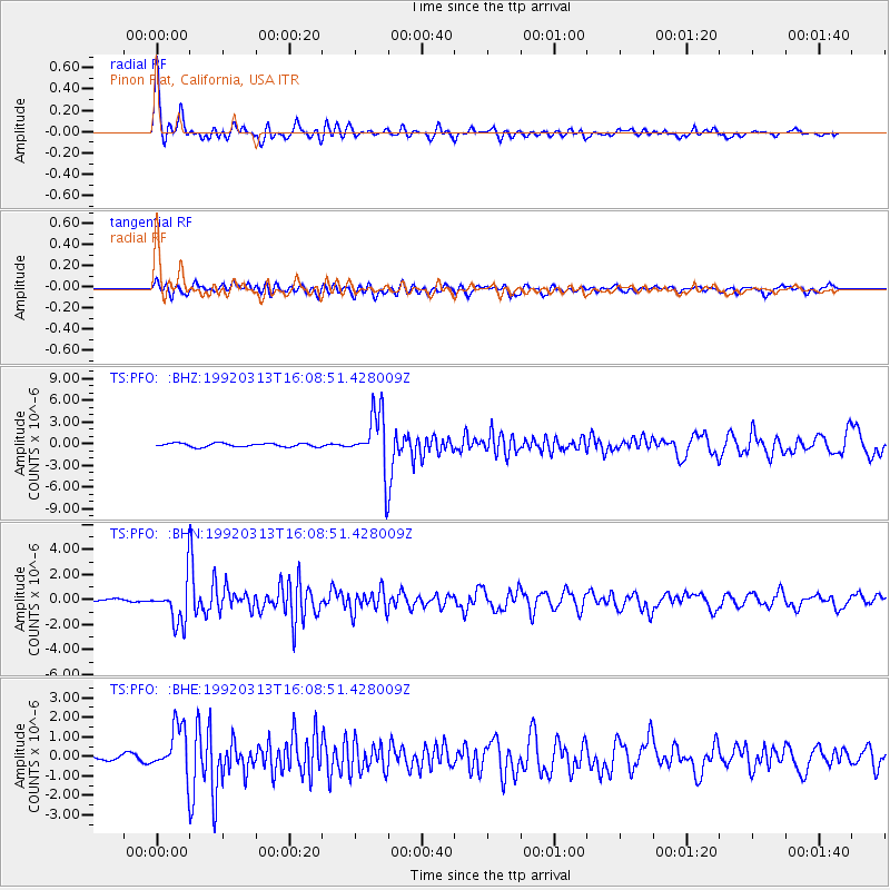
Signal To Noise
| Channel | StoN | STA | LTA |
| TS:PFO: :BHN:19920313T16:08:51.428009Z | 8.031657 | 1.6484639E-6 | 2.0524581E-7 |
| TS:PFO: :BHE:19920313T16:08:51.428009Z | 5.8090906 | 1.2011917E-6 | 2.0677794E-7 |
| TS:PFO: :BHZ:19920313T16:08:51.428009Z | 16.217167 | 3.981502E-6 | 2.4551153E-7 |
| Arrivals |
| Ps | 3.8 SECOND |
| PpPs | 12 SECOND |
| PsPs/PpSs | 16 SECOND |


