You are here: Home > Network List > MN - MEDNET Project Stations List
> Station VSL Villasalto, Italy > Earthquake Result Viewer
VSL Villasalto, Italy - Earthquake Result Viewer
| Earthquake location: |
Kuril Islands |
| Earthquake latitude/longitude: |
48.7/154.9 |
| Earthquake time(UTC): |
1991/07/13 (194) 12:15:13 GMT |
| Earthquake Depth: |
40 km |
| Earthquake Magnitude: |
5.7 MB, 5.9 MS, 5.7 UNKNOWN |
| Earthquake Catalog/Contributor: |
WHDF/NEIC |
|
| Network: |
MN MEDNET Project |
| Station: |
VSL Villasalto, Italy |
| Lat/Lon: |
39.50 N/9.38 E |
| Elevation: |
370 m |
|
| Distance: |
87.0 deg |
| Az: |
334.016 deg |
| Baz: |
22.018 deg |
| Ray Param: |
0.043575656 |
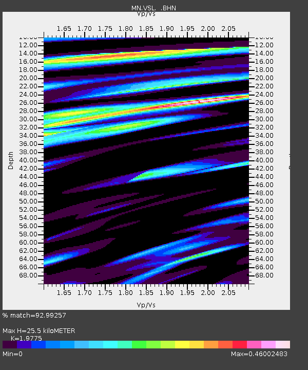
| Estimated Moho Depth: |
25.5 km |
| Estimated Crust Vp/Vs: |
1.98 |
| Assumed Crust Vp: |
6.183 km/s |
| Estimated Crust Vs: |
3.126 km/s |
| Estimated Crust Poisson's Ratio: |
0.33 |
|
| Radial Match: |
92.99257 % |
| Radial Bump: |
395 |
| Transverse Match: |
87.787186 % |
| Transverse Bump: |
400 |
| SOD ConfigId: |
17000 |
| Insert Time: |
2010-03-08 17:44:20.672 +0000 |
| GWidth: |
2.5 |
| Max Bumps: |
400 |
| Tol: |
0.001 |
|

Signal To Noise
| Channel | StoN | STA | LTA |
| MN:VSL: :BHN:19910713T12:27:23.166003Z | 9.949717 | 4.2354722E-7 | 4.256877E-8 |
| MN:VSL: :BHE:19910713T12:27:23.166003Z | 3.9710748 | 1.18971954E-7 | 2.9959637E-8 |
| MN:VSL: :BHZ:19910713T12:27:23.166003Z | 27.239107 | 1.2747417E-6 | 4.6798224E-8 |
| Arrivals |
| Ps | 4.1 SECOND |
| PpPs | 12 SECOND |
| PsPs/PpSs | 16 SECOND |


