You are here: Home > Network List > UW - Pacific Northwest Regional Seismic Network Stations List
> Station DDRF Dider Farm, Eltopia, WA, USA > Earthquake Result Viewer
DDRF Dider Farm, Eltopia, WA, USA - Earthquake Result Viewer
| Earthquake location: |
Cuba Region |
| Earthquake latitude/longitude: |
19.3/-78.8 |
| Earthquake time(UTC): |
2020/01/28 (028) 19:10:23 GMT |
| Earthquake Depth: |
10 km |
| Earthquake Magnitude: |
7.3 Mi |
| Earthquake Catalog/Contributor: |
NEIC PDE/pt |
|
| Network: |
UW Pacific Northwest Regional Seismic Network |
| Station: |
DDRF Dider Farm, Eltopia, WA, USA |
| Lat/Lon: |
46.49 N/119.06 W |
| Elevation: |
233 m |
|
| Distance: |
42.6 deg |
| Az: |
318.772 deg |
| Baz: |
115.726 deg |
| Ray Param: |
0.07306394 |
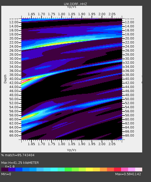
| Estimated Moho Depth: |
41.25 km |
| Estimated Crust Vp/Vs: |
1.60 |
| Assumed Crust Vp: |
6.419 km/s |
| Estimated Crust Vs: |
4.012 km/s |
| Estimated Crust Poisson's Ratio: |
0.18 |
|
| Radial Match: |
95.743484 % |
| Radial Bump: |
282 |
| Transverse Match: |
81.31462 % |
| Transverse Bump: |
368 |
| SOD ConfigId: |
20465011 |
| Insert Time: |
2020-02-11 19:24:46.986 +0000 |
| GWidth: |
2.5 |
| Max Bumps: |
400 |
| Tol: |
0.001 |
|

Signal To Noise
| Channel | StoN | STA | LTA |
| UW:DDRF: :HHZ:20200128T19:17:48.537994Z | 2.000659 | 1.0148638E-6 | 5.072647E-7 |
| UW:DDRF: :HHN:20200128T19:17:48.537994Z | 2.8294122 | 6.579453E-7 | 2.3253779E-7 |
| UW:DDRF: :HHE:20200128T19:17:48.537994Z | 2.094589 | 6.5077313E-7 | 3.106925E-7 |
| Arrivals |
| Ps | 4.2 SECOND |
| PpPs | 16 SECOND |
| PsPs/PpSs | 20 SECOND |


