You are here: Home > Network List > UW - Pacific Northwest Regional Seismic Network Stations List
> Station RATT Rattlesnake Lake, King County, WA > Earthquake Result Viewer
RATT Rattlesnake Lake, King County, WA - Earthquake Result Viewer
| Earthquake location: |
Cuba Region |
| Earthquake latitude/longitude: |
19.3/-78.8 |
| Earthquake time(UTC): |
2020/01/28 (028) 19:10:23 GMT |
| Earthquake Depth: |
10 km |
| Earthquake Magnitude: |
7.3 Mi |
| Earthquake Catalog/Contributor: |
NEIC PDE/pt |
|
| Network: |
UW Pacific Northwest Regional Seismic Network |
| Station: |
RATT Rattlesnake Lake, King County, WA |
| Lat/Lon: |
47.43 N/121.80 W |
| Elevation: |
442 m |
|
| Distance: |
44.7 deg |
| Az: |
318.861 deg |
| Baz: |
113.792 deg |
| Ray Param: |
0.07174597 |
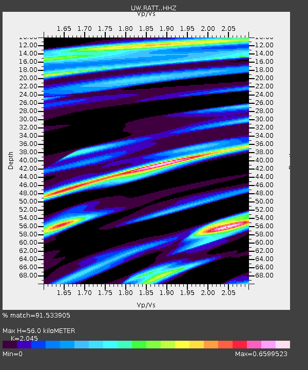
| Estimated Moho Depth: |
56.0 km |
| Estimated Crust Vp/Vs: |
2.05 |
| Assumed Crust Vp: |
6.597 km/s |
| Estimated Crust Vs: |
3.226 km/s |
| Estimated Crust Poisson's Ratio: |
0.34 |
|
| Radial Match: |
91.533905 % |
| Radial Bump: |
400 |
| Transverse Match: |
84.8668 % |
| Transverse Bump: |
400 |
| SOD ConfigId: |
20465011 |
| Insert Time: |
2020-02-11 19:25:13.478 +0000 |
| GWidth: |
2.5 |
| Max Bumps: |
400 |
| Tol: |
0.001 |
|

Signal To Noise
| Channel | StoN | STA | LTA |
| UW:RATT: :HHZ:20200128T19:18:05.399994Z | 1.7813469 | 9.2043217E-7 | 5.167057E-7 |
| UW:RATT: :HHN:20200128T19:18:05.399994Z | 0.5781475 | 2.900522E-7 | 5.016924E-7 |
| UW:RATT: :HHE:20200128T19:18:05.399994Z | 1.5140332 | 6.7787965E-7 | 4.4773103E-7 |
| Arrivals |
| Ps | 9.4 SECOND |
| PpPs | 24 SECOND |
| PsPs/PpSs | 34 SECOND |


