You are here: Home > Network List > MN - MEDNET Project Stations List
> Station VSL Villasalto, Italy > Earthquake Result Viewer
VSL Villasalto, Italy - Earthquake Result Viewer
| Earthquake location: |
Near Coast Of Northern Calif. |
| Earthquake latitude/longitude: |
40.4/-124.3 |
| Earthquake time(UTC): |
1992/04/25 (116) 18:06:04 GMT |
| Earthquake Depth: |
15 km |
| Earthquake Magnitude: |
6.4 MB, 7.1 MS |
| Earthquake Catalog/Contributor: |
WHDF/NEIC |
|
| Network: |
MN MEDNET Project |
| Station: |
VSL Villasalto, Italy |
| Lat/Lon: |
39.50 N/9.38 E |
| Elevation: |
370 m |
|
| Distance: |
90.0 deg |
| Az: |
34.018 deg |
| Baz: |
326.466 deg |
| Ray Param: |
0.041705057 |
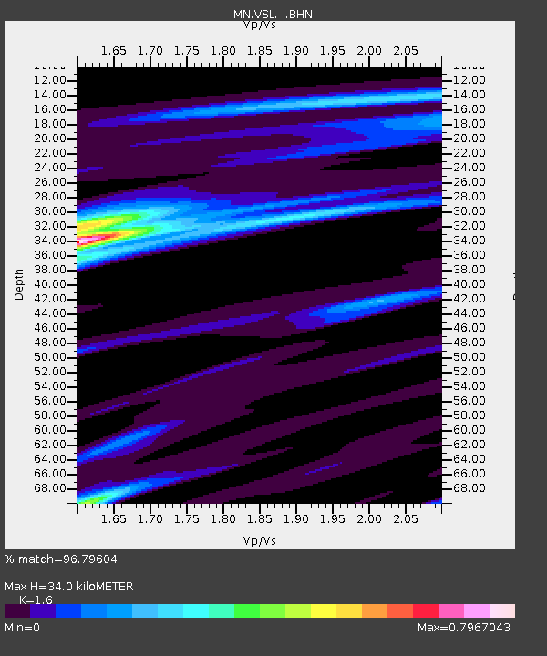
| Estimated Moho Depth: |
34.0 km |
| Estimated Crust Vp/Vs: |
1.60 |
| Assumed Crust Vp: |
6.183 km/s |
| Estimated Crust Vs: |
3.864 km/s |
| Estimated Crust Poisson's Ratio: |
0.18 |
|
| Radial Match: |
96.79604 % |
| Radial Bump: |
400 |
| Transverse Match: |
90.835655 % |
| Transverse Bump: |
400 |
| SOD ConfigId: |
16938 |
| Insert Time: |
2010-03-08 17:44:34.880 +0000 |
| GWidth: |
2.5 |
| Max Bumps: |
400 |
| Tol: |
0.001 |
|

Signal To Noise
| Channel | StoN | STA | LTA |
| MN:VSL: :BHN:19920425T18:18:31.340015Z | 15.947693 | 2.1805442E-6 | 1.36731E-7 |
| MN:VSL: :BHE:19920425T18:18:31.340015Z | 10.736321 | 1.717802E-6 | 1.5999912E-7 |
| MN:VSL: :BHZ:19920425T18:18:31.340015Z | 39.58978 | 7.684912E-6 | 1.9411354E-7 |
| Arrivals |
| Ps | 3.4 SECOND |
| PpPs | 14 SECOND |
| PsPs/PpSs | 17 SECOND |


