You are here: Home > Network List > AV - Alaska Volcano Observatory Stations List
> Station SPCR Ckakachatna River, Mount Spurr, Alaska > Earthquake Result Viewer
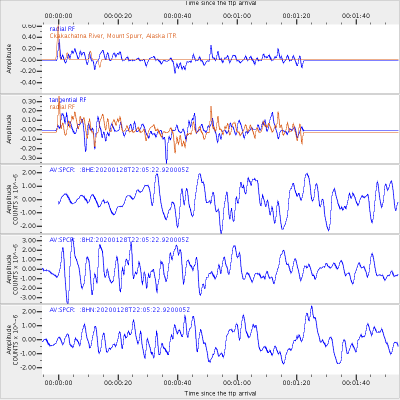
SPCR Ckakachatna River, Mount Spurr, Alaska - Earthquake Result Viewer
*The percent match for this event was below the threshold and hence no stack was calculated.
| Earthquake location: |
North Of Honduras |
| Earthquake latitude/longitude: |
18.9/-80.7 |
| Earthquake time(UTC): |
2020/01/28 (028) 21:55:16 GMT |
| Earthquake Depth: |
10 km |
| Earthquake Magnitude: |
6.1 mww |
| Earthquake Catalog/Contributor: |
NEIC PDE/us |
|
| Network: |
AV Alaska Volcano Observatory |
| Station: |
SPCR Ckakachatna River, Mount Spurr, Alaska |
| Lat/Lon: |
61.20 N/152.21 W |
| Elevation: |
984 m |
|
| Distance: |
64.7 deg |
| Az: |
329.466 deg |
| Baz: |
96.771 deg |
| Ray Param: |
$rayparam |
*The percent match for this event was below the threshold and hence was not used in the summary stack. |
|
| Radial Match: |
74.25935 % |
| Radial Bump: |
400 |
| Transverse Match: |
70.0743 % |
| Transverse Bump: |
400 |
| SOD ConfigId: |
20465011 |
| Insert Time: |
2020-02-11 21:58:19.576 +0000 |
| GWidth: |
2.5 |
| Max Bumps: |
400 |
| Tol: |
0.001 |
|
Signal To Noise
| Channel | StoN | STA | LTA |
| AV:SPCR: :BHZ:20200128T22:05:22.920005Z | 2.6088536 | 1.9121549E-6 | 7.3294837E-7 |
| AV:SPCR: :BHN:20200128T22:05:22.920005Z | 0.64266825 | 2.729275E-7 | 4.2467866E-7 |
| AV:SPCR: :BHE:20200128T22:05:22.920005Z | 3.012897 | 1.1497642E-6 | 3.8161417E-7 |
| Arrivals |
| Ps | |
| PpPs | |
| PsPs/PpSs | |


