You are here: Home > Network List > TS - TERRAscope (Southern California Seismic Network) Stations List
> Station PFO Pinon Flat, California, USA > Earthquake Result Viewer
PFO Pinon Flat, California, USA - Earthquake Result Viewer
| Earthquake location: |
Cuba Region |
| Earthquake latitude/longitude: |
19.6/-77.9 |
| Earthquake time(UTC): |
1992/05/25 (146) 16:55:05 GMT |
| Earthquake Depth: |
33 km |
| Earthquake Magnitude: |
6.3 MB, 7.0 MS |
| Earthquake Catalog/Contributor: |
WHDF/NEIC |
|
| Network: |
TS TERRAscope (Southern California Seismic Network) |
| Station: |
PFO Pinon Flat, California, USA |
| Lat/Lon: |
33.61 N/116.46 W |
| Elevation: |
1280 m |
|
| Distance: |
37.0 deg |
| Az: |
300.128 deg |
| Baz: |
102.269 deg |
| Ray Param: |
0.07630906 |
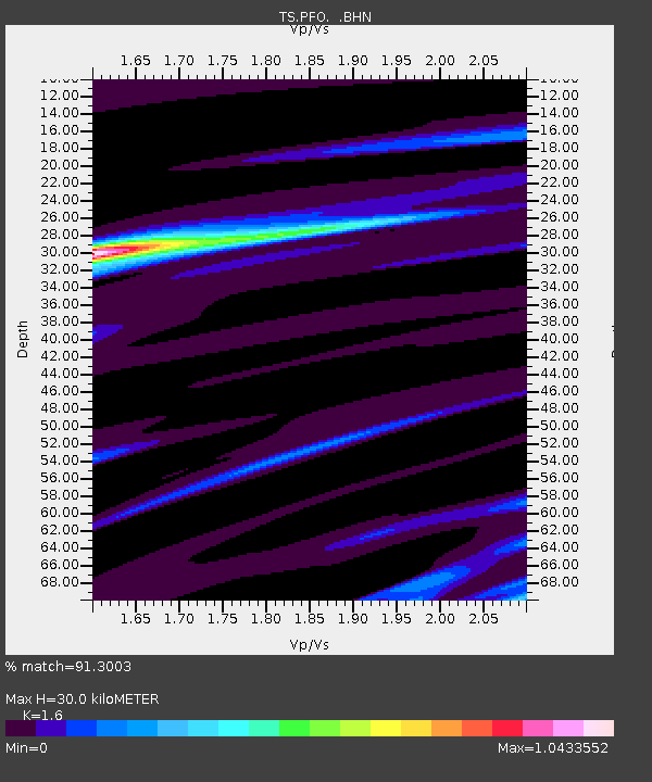
| Estimated Moho Depth: |
30.0 km |
| Estimated Crust Vp/Vs: |
1.60 |
| Assumed Crust Vp: |
6.264 km/s |
| Estimated Crust Vs: |
3.915 km/s |
| Estimated Crust Poisson's Ratio: |
0.18 |
|
| Radial Match: |
91.3003 % |
| Radial Bump: |
197 |
| Transverse Match: |
78.9829 % |
| Transverse Bump: |
363 |
| SOD ConfigId: |
16938 |
| Insert Time: |
2010-02-26 14:41:46.007 +0000 |
| GWidth: |
2.5 |
| Max Bumps: |
400 |
| Tol: |
0.001 |
|

Signal To Noise
| Channel | StoN | STA | LTA |
| TS:PFO: :BHN:19920525T17:01:41.37901Z | 2.6738 | 1.4756249E-7 | 5.5188305E-8 |
| TS:PFO: :BHE:19920525T17:01:41.37901Z | 13.420976 | 7.231963E-7 | 5.3885522E-8 |
| TS:PFO: :BHZ:19920525T17:01:41.37901Z | 11.123622 | 1.0026989E-6 | 9.0141405E-8 |
| Arrivals |
| Ps | 3.1 SECOND |
| PpPs | 12 SECOND |
| PsPs/PpSs | 15 SECOND |


