You are here: Home > Network List > CI - Caltech Regional Seismic Network Stations List
> Station SWS Sam W. Stewart, Westmorland, CA, USA > Earthquake Result Viewer
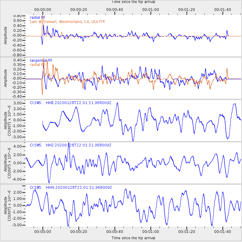
SWS Sam W. Stewart, Westmorland, CA, USA - Earthquake Result Viewer
*The percent match for this event was below the threshold and hence no stack was calculated.
| Earthquake location: |
North Of Honduras |
| Earthquake latitude/longitude: |
18.9/-80.7 |
| Earthquake time(UTC): |
2020/01/28 (028) 21:55:16 GMT |
| Earthquake Depth: |
10 km |
| Earthquake Magnitude: |
6.1 mww |
| Earthquake Catalog/Contributor: |
NEIC PDE/us |
|
| Network: |
CI Caltech Regional Seismic Network |
| Station: |
SWS Sam W. Stewart, Westmorland, CA, USA |
| Lat/Lon: |
32.94 N/115.80 W |
| Elevation: |
140 m |
|
| Distance: |
34.3 deg |
| Az: |
300.98 deg |
| Baz: |
105.201 deg |
| Ray Param: |
$rayparam |
*The percent match for this event was below the threshold and hence was not used in the summary stack. |
|
| Radial Match: |
50.28379 % |
| Radial Bump: |
400 |
| Transverse Match: |
50.332123 % |
| Transverse Bump: |
374 |
| SOD ConfigId: |
20465011 |
| Insert Time: |
2020-02-11 22:01:42.597 +0000 |
| GWidth: |
2.5 |
| Max Bumps: |
400 |
| Tol: |
0.001 |
|
Signal To Noise
| Channel | StoN | STA | LTA |
| CI:SWS: :HHZ:20200128T22:01:31.968009Z | 3.074202 | 2.1945382E-6 | 7.138562E-7 |
| CI:SWS: :HHN:20200128T22:01:31.968009Z | 0.82418877 | 1.1697583E-6 | 1.4192844E-6 |
| CI:SWS: :HHE:20200128T22:01:31.968009Z | 0.8777337 | 1.0397117E-6 | 1.1845411E-6 |
| Arrivals |
| Ps | |
| PpPs | |
| PsPs/PpSs | |


