You are here: Home > Network List > TS - TERRAscope (Southern California Seismic Network) Stations List
> Station PFO Pinon Flat, California, USA > Earthquake Result Viewer
PFO Pinon Flat, California, USA - Earthquake Result Viewer
| Earthquake location: |
East Of Kuril Islands |
| Earthquake latitude/longitude: |
47.6/155.6 |
| Earthquake time(UTC): |
1992/05/28 (149) 21:24:50 GMT |
| Earthquake Depth: |
49 km |
| Earthquake Magnitude: |
6.0 MB, 5.3 MS |
| Earthquake Catalog/Contributor: |
WHDF/NEIC |
|
| Network: |
TS TERRAscope (Southern California Seismic Network) |
| Station: |
PFO Pinon Flat, California, USA |
| Lat/Lon: |
33.61 N/116.46 W |
| Elevation: |
1280 m |
|
| Distance: |
64.8 deg |
| Az: |
67.202 deg |
| Baz: |
311.606 deg |
| Ray Param: |
0.058602754 |
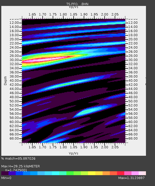
| Estimated Moho Depth: |
29.25 km |
| Estimated Crust Vp/Vs: |
1.74 |
| Assumed Crust Vp: |
6.264 km/s |
| Estimated Crust Vs: |
3.595 km/s |
| Estimated Crust Poisson's Ratio: |
0.25 |
|
| Radial Match: |
85.897026 % |
| Radial Bump: |
400 |
| Transverse Match: |
64.27456 % |
| Transverse Bump: |
400 |
| SOD ConfigId: |
16938 |
| Insert Time: |
2010-02-26 14:41:48.418 +0000 |
| GWidth: |
2.5 |
| Max Bumps: |
400 |
| Tol: |
0.001 |
|
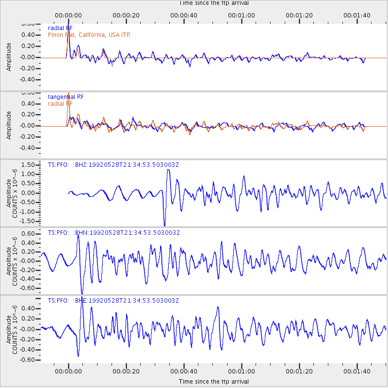
Signal To Noise
| Channel | StoN | STA | LTA |
| TS:PFO: :BHN:19920528T21:34:53.503003Z | 2.2539985 | 3.064769E-7 | 1.3597031E-7 |
| TS:PFO: :BHE:19920528T21:34:53.503003Z | 3.5304577 | 2.631511E-7 | 7.453738E-8 |
| TS:PFO: :BHZ:19920528T21:34:53.503003Z | 3.9603539 | 7.113988E-7 | 1.796301E-7 |
| Arrivals |
| Ps | 3.6 SECOND |
| PpPs | 12 SECOND |
| PsPs/PpSs | 16 SECOND |


