You are here: Home > Network List > TA - USArray Transportable Network (new EarthScope stations) Stations List
> Station H16K Elim, AK, USA > Earthquake Result Viewer
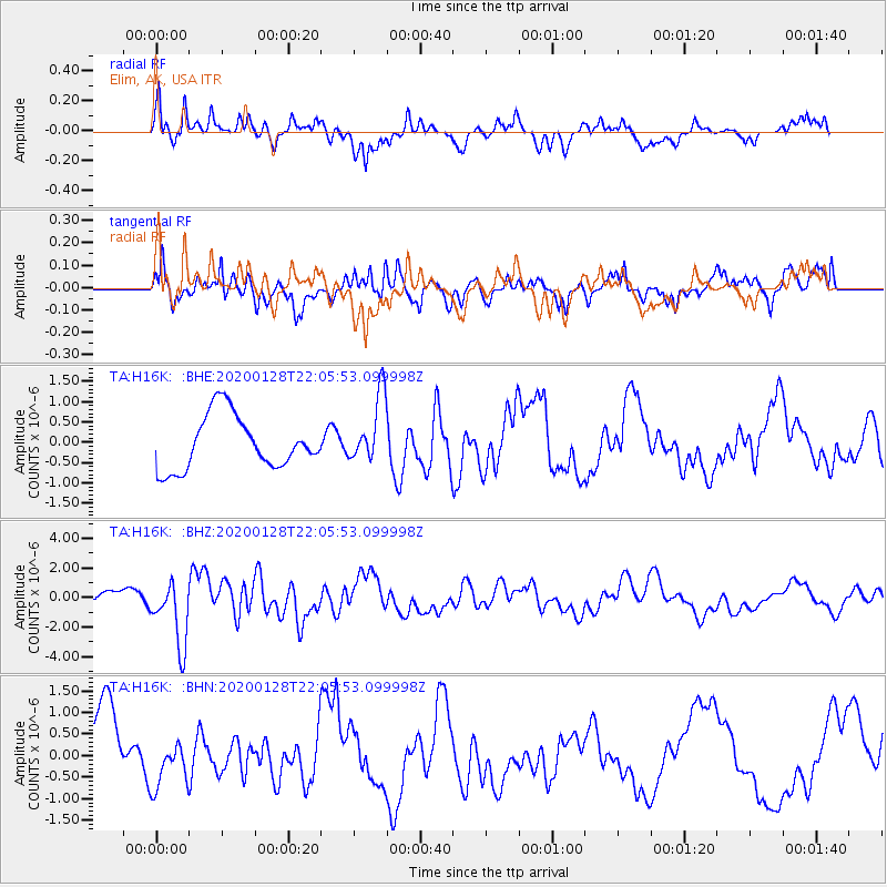
H16K Elim, AK, USA - Earthquake Result Viewer
*The percent match for this event was below the threshold and hence no stack was calculated.
| Earthquake location: |
North Of Honduras |
| Earthquake latitude/longitude: |
18.9/-80.7 |
| Earthquake time(UTC): |
2020/01/28 (028) 21:55:16 GMT |
| Earthquake Depth: |
10 km |
| Earthquake Magnitude: |
6.1 mww |
| Earthquake Catalog/Contributor: |
NEIC PDE/us |
|
| Network: |
TA USArray Transportable Network (new EarthScope stations) |
| Station: |
H16K Elim, AK, USA |
| Lat/Lon: |
64.64 N/162.24 W |
| Elevation: |
216 m |
|
| Distance: |
69.4 deg |
| Az: |
332.935 deg |
| Baz: |
89.198 deg |
| Ray Param: |
$rayparam |
*The percent match for this event was below the threshold and hence was not used in the summary stack. |
|
| Radial Match: |
81.32745 % |
| Radial Bump: |
398 |
| Transverse Match: |
61.070915 % |
| Transverse Bump: |
400 |
| SOD ConfigId: |
20465011 |
| Insert Time: |
2020-02-11 22:08:00.303 +0000 |
| GWidth: |
2.5 |
| Max Bumps: |
400 |
| Tol: |
0.001 |
|
Signal To Noise
| Channel | StoN | STA | LTA |
| TA:H16K: :BHZ:20200128T22:05:53.099998Z | 7.0537453 | 2.1850353E-6 | 3.0976955E-7 |
| TA:H16K: :BHN:20200128T22:05:53.099998Z | 0.7344651 | 5.276669E-7 | 7.184369E-7 |
| TA:H16K: :BHE:20200128T22:05:53.099998Z | 1.2644632 | 8.3346964E-7 | 6.5914895E-7 |
| Arrivals |
| Ps | |
| PpPs | |
| PsPs/PpSs | |


