You are here: Home > Network List > TA - USArray Transportable Network (new EarthScope stations) Stations List
> Station H31M Peel River, Yukon, CAN > Earthquake Result Viewer
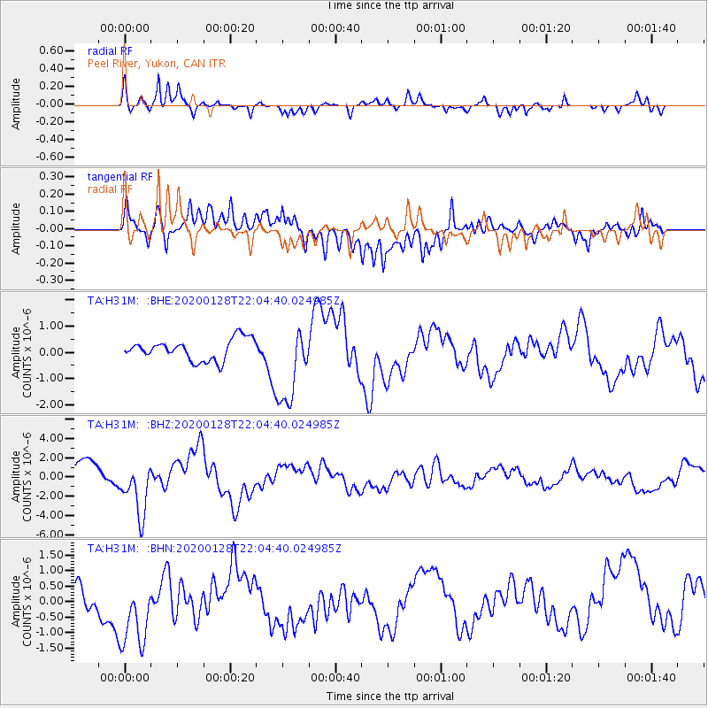
H31M Peel River, Yukon, CAN - Earthquake Result Viewer
*The percent match for this event was below the threshold and hence no stack was calculated.
| Earthquake location: |
North Of Honduras |
| Earthquake latitude/longitude: |
18.9/-80.7 |
| Earthquake time(UTC): |
2020/01/28 (028) 21:55:16 GMT |
| Earthquake Depth: |
10 km |
| Earthquake Magnitude: |
6.1 mww |
| Earthquake Catalog/Contributor: |
NEIC PDE/us |
|
| Network: |
TA USArray Transportable Network (new EarthScope stations) |
| Station: |
H31M Peel River, Yukon, CAN |
| Lat/Lon: |
65.81 N/134.34 W |
| Elevation: |
642 m |
|
| Distance: |
58.3 deg |
| Az: |
337.045 deg |
| Baz: |
116.405 deg |
| Ray Param: |
$rayparam |
*The percent match for this event was below the threshold and hence was not used in the summary stack. |
|
| Radial Match: |
86.610115 % |
| Radial Bump: |
400 |
| Transverse Match: |
43.527096 % |
| Transverse Bump: |
400 |
| SOD ConfigId: |
20465011 |
| Insert Time: |
2020-02-11 22:08:10.068 +0000 |
| GWidth: |
2.5 |
| Max Bumps: |
400 |
| Tol: |
0.001 |
|
Signal To Noise
| Channel | StoN | STA | LTA |
| TA:H31M: :BHZ:20200128T22:04:40.024985Z | 2.8812633 | 2.8838251E-6 | 1.0008891E-6 |
| TA:H31M: :BHN:20200128T22:04:40.024985Z | 3.3302739 | 1.4453531E-6 | 4.3400425E-7 |
| TA:H31M: :BHE:20200128T22:04:40.024985Z | 3.7672596 | 1.5092962E-6 | 4.0063503E-7 |
| Arrivals |
| Ps | |
| PpPs | |
| PsPs/PpSs | |


