You are here: Home > Network List > TA - USArray Transportable Network (new EarthScope stations) Stations List
> Station I17K Unalakleet, AK, USA > Earthquake Result Viewer
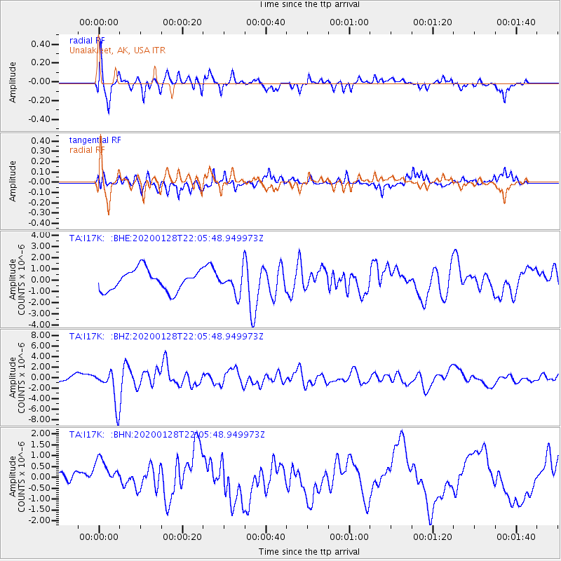
I17K Unalakleet, AK, USA - Earthquake Result Viewer
*The percent match for this event was below the threshold and hence no stack was calculated.
| Earthquake location: |
North Of Honduras |
| Earthquake latitude/longitude: |
18.9/-80.7 |
| Earthquake time(UTC): |
2020/01/28 (028) 21:55:16 GMT |
| Earthquake Depth: |
10 km |
| Earthquake Magnitude: |
6.1 mww |
| Earthquake Catalog/Contributor: |
NEIC PDE/us |
|
| Network: |
TA USArray Transportable Network (new EarthScope stations) |
| Station: |
I17K Unalakleet, AK, USA |
| Lat/Lon: |
63.89 N/160.70 W |
| Elevation: |
105 m |
|
| Distance: |
68.8 deg |
| Az: |
332.125 deg |
| Baz: |
90.298 deg |
| Ray Param: |
$rayparam |
*The percent match for this event was below the threshold and hence was not used in the summary stack. |
|
| Radial Match: |
69.780945 % |
| Radial Bump: |
400 |
| Transverse Match: |
62.402378 % |
| Transverse Bump: |
400 |
| SOD ConfigId: |
20465011 |
| Insert Time: |
2020-02-11 22:08:10.934 +0000 |
| GWidth: |
2.5 |
| Max Bumps: |
400 |
| Tol: |
0.001 |
|
Signal To Noise
| Channel | StoN | STA | LTA |
| TA:I17K: :BHZ:20200128T22:05:48.949973Z | 3.90258 | 3.4490195E-6 | 8.8377925E-7 |
| TA:I17K: :BHN:20200128T22:05:48.949973Z | 0.8674256 | 7.683689E-7 | 8.858038E-7 |
| TA:I17K: :BHE:20200128T22:05:48.949973Z | 1.1627761 | 1.0712855E-6 | 9.213171E-7 |
| Arrivals |
| Ps | |
| PpPs | |
| PsPs/PpSs | |


