You are here: Home > Network List > MN - MEDNET Project Stations List
> Station VSL Villasalto, Italy > Earthquake Result Viewer
VSL Villasalto, Italy - Earthquake Result Viewer

| Earthquake location: |
Kuril Islands |
| Earthquake latitude/longitude: |
44.6/149.4 |
| Earthquake time(UTC): |
1995/12/03 (337) 18:01:08 GMT |
| Earthquake Depth: |
33 km |
| Earthquake Magnitude: |
6.6 MB, 8.0 MS |
| Earthquake Catalog/Contributor: |
WHDF/NEIC |
|
| Network: |
MN MEDNET Project |
| Station: |
VSL Villasalto, Italy |
| Lat/Lon: |
39.50 N/9.38 E |
| Elevation: |
370 m |
|
| Distance: |
88.9 deg |
| Az: |
330.166 deg |
| Baz: |
27.359 deg |
| Ray Param: |
0.042208705 |
| Estimated Moho Depth: |
27.0 km |
| Estimated Crust Vp/Vs: |
1.84 |
| Assumed Crust Vp: |
6.183 km/s |
| Estimated Crust Vs: |
3.365 km/s |
| Estimated Crust Poisson's Ratio: |
0.29 |
|
| Radial Match: |
96.66071 % |
| Radial Bump: |
358 |
| Transverse Match: |
92.18757 % |
| Transverse Bump: |
400 |
| SOD ConfigId: |
6273 |
| Insert Time: |
2010-03-08 17:46:01.573 +0000 |
| GWidth: |
2.5 |
| Max Bumps: |
400 |
| Tol: |
0.001 |
|
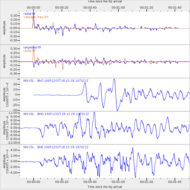
Signal To Noise
| Channel | StoN | STA | LTA |
| MN:VSL: :BHN:19951203T18:13:28.197021Z | 2.4709334 | 4.3989255E-7 | 1.7802687E-7 |
| MN:VSL: :BHE:19951203T18:13:28.197021Z | 1.7725201 | 1.11352826E-7 | 6.2821755E-8 |
| MN:VSL: :BHZ:19951203T18:13:28.197021Z | 5.4655714 | 1.5914281E-6 | 2.9117325E-7 |
| Arrivals |
| Ps | 3.7 SECOND |
| PpPs | 12 SECOND |
| PsPs/PpSs | 16 SECOND |


