You are here: Home > Network List > US - United States National Seismic Network Stations List
> Station EGMT Eagleton, Montana, USA > Earthquake Result Viewer
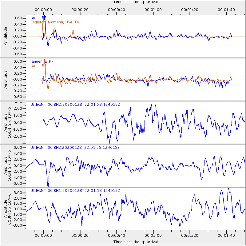
EGMT Eagleton, Montana, USA - Earthquake Result Viewer
*The percent match for this event was below the threshold and hence no stack was calculated.
| Earthquake location: |
North Of Honduras |
| Earthquake latitude/longitude: |
18.9/-80.7 |
| Earthquake time(UTC): |
2020/01/28 (028) 21:55:16 GMT |
| Earthquake Depth: |
10 km |
| Earthquake Magnitude: |
6.1 mww |
| Earthquake Catalog/Contributor: |
NEIC PDE/us |
|
| Network: |
US United States National Seismic Network |
| Station: |
EGMT Eagleton, Montana, USA |
| Lat/Lon: |
48.02 N/109.75 W |
| Elevation: |
1055 m |
|
| Distance: |
37.4 deg |
| Az: |
327.531 deg |
| Baz: |
130.807 deg |
| Ray Param: |
$rayparam |
*The percent match for this event was below the threshold and hence was not used in the summary stack. |
|
| Radial Match: |
71.92358 % |
| Radial Bump: |
400 |
| Transverse Match: |
51.7455 % |
| Transverse Bump: |
400 |
| SOD ConfigId: |
20465011 |
| Insert Time: |
2020-02-11 22:09:46.444 +0000 |
| GWidth: |
2.5 |
| Max Bumps: |
400 |
| Tol: |
0.001 |
|
Signal To Noise
| Channel | StoN | STA | LTA |
| US:EGMT:00:BHZ:20200128T22:01:58.124015Z | 2.8909385 | 2.782506E-6 | 9.624922E-7 |
| US:EGMT:00:BH1:20200128T22:01:58.124015Z | 1.1284907 | 1.2312973E-6 | 1.0911011E-6 |
| US:EGMT:00:BH2:20200128T22:01:58.124015Z | 2.3755271 | 1.0273861E-6 | 4.324876E-7 |
| Arrivals |
| Ps | |
| PpPs | |
| PsPs/PpSs | |


