You are here: Home > Network List > TS - TERRAscope (Southern California Seismic Network) Stations List
> Station PFO Pinon Flat, California, USA > Earthquake Result Viewer
PFO Pinon Flat, California, USA - Earthquake Result Viewer
| Earthquake location: |
Off East Coast Of Honshu, Japan |
| Earthquake latitude/longitude: |
39.4/143.5 |
| Earthquake time(UTC): |
1992/07/29 (211) 04:30:49 GMT |
| Earthquake Depth: |
29 km |
| Earthquake Magnitude: |
5.9 MB, 6.1 MS, 6.1 UNKNOWN |
| Earthquake Catalog/Contributor: |
WHDF/NEIC |
|
| Network: |
TS TERRAscope (Southern California Seismic Network) |
| Station: |
PFO Pinon Flat, California, USA |
| Lat/Lon: |
33.61 N/116.46 W |
| Elevation: |
1280 m |
|
| Distance: |
76.3 deg |
| Az: |
57.757 deg |
| Baz: |
308.295 deg |
| Ray Param: |
0.05102729 |
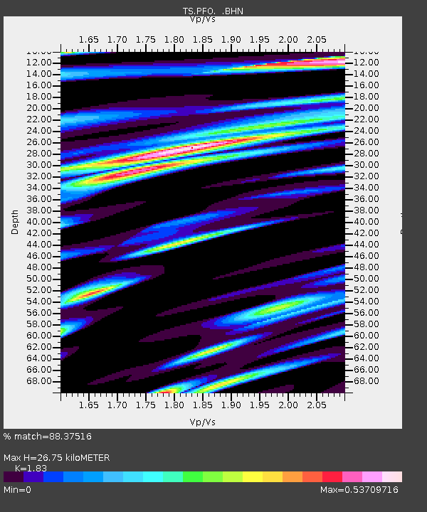
| Estimated Moho Depth: |
26.75 km |
| Estimated Crust Vp/Vs: |
1.83 |
| Assumed Crust Vp: |
6.264 km/s |
| Estimated Crust Vs: |
3.423 km/s |
| Estimated Crust Poisson's Ratio: |
0.29 |
|
| Radial Match: |
88.37516 % |
| Radial Bump: |
400 |
| Transverse Match: |
66.111786 % |
| Transverse Bump: |
400 |
| SOD ConfigId: |
16938 |
| Insert Time: |
2010-02-26 14:41:52.293 +0000 |
| GWidth: |
2.5 |
| Max Bumps: |
400 |
| Tol: |
0.001 |
|
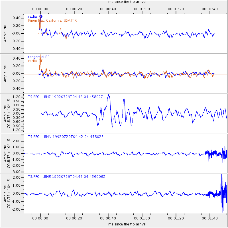
Signal To Noise
| Channel | StoN | STA | LTA |
| TS:PFO: :BHN:19920729T04:42:04.45802Z | 1.2902827 | 9.639598E-8 | 7.470919E-8 |
| TS:PFO: :BHE:19920729T04:42:04.456006Z | 1.1424346 | 1.0108613E-7 | 8.848308E-8 |
| TS:PFO: :BHZ:19920729T04:42:04.45802Z | 3.2255535 | 3.6082068E-7 | 1.1186319E-7 |
| Arrivals |
| Ps | 3.6 SECOND |
| PpPs | 12 SECOND |
| PsPs/PpSs | 15 SECOND |


