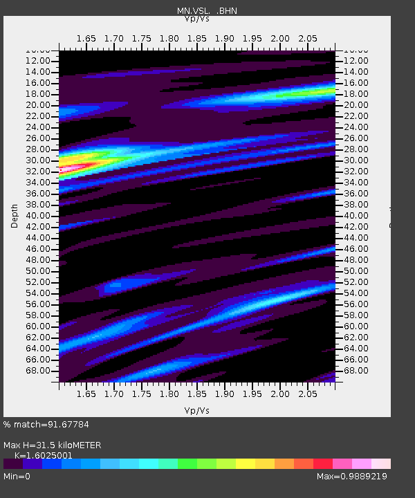
VSL Villasalto, Italy - Earthquake Result Viewer
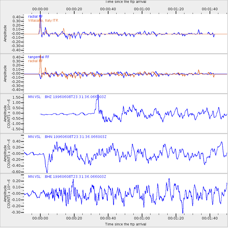
Earthquake location: Andreanof Islands, Aleutian Is.
Earthquake latitude/longitude: 51.5/-178.1
Earthquake time(UTC): 1996/06/08 (160) 23:19:15 GMT
Earthquake Depth: 33 km
Earthquake Magnitude: 5.9 MB, 6.3 MS, 6.5 UNKNOWN, 6.1 MS
Earthquake Catalog/Contributor: WHDF/NEIC
Network: MN MEDNET Project
Station: VSL Villasalto, Italy
Lat/Lon: 39.50 N/9.38 E
Elevation: 370 m
Distance: 89.2 deg
Az: 354.198 deg
Baz: 4.685 deg
Ray Param: 0.042017706
Estimated Moho Depth: 31.5 km
Estimated Crust Vp/Vs: 1.60
Assumed Crust Vp: 6.183 km/s
Estimated Crust Vs: 3.858 km/s
Estimated Crust Poisson's Ratio: 0.18
Radial Match: 91.67784 %
Radial Bump: 400
Transverse Match: 62.87161 %
Transverse Bump: 400
SOD ConfigId: 6273
Insert Time: 2010-03-08 17:46:09.232 +0000
GWidth: 2.5
Max Bumps: 400
Tol: 0.001

Signal To Noise

ChannelStoNSTALTA
MN:VSL: :BHN:19960608T23:31:36.066003Z11.3436562.7312583E-72.407741E-8
MN:VSL: :BHE:19960608T23:31:36.066003Z1.33133283.1504854E-82.3664146E-8
MN:VSL: :BHZ:19960608T23:31:36.066003Z14.9475927.6452955E-75.114734E-8
Arrivals
Ps3.1 SECOND
PpPs13 SECOND
PsPs/PpSs16 SECOND