You are here: Home > Network List > TS - TERRAscope (Southern California Seismic Network) Stations List
> Station PFO Pinon Flat, California, USA > Earthquake Result Viewer
PFO Pinon Flat, California, USA - Earthquake Result Viewer
| Earthquake location: |
Southeast Of Honshu, Japan |
| Earthquake latitude/longitude: |
32.5/141.7 |
| Earthquake time(UTC): |
1992/08/11 (224) 15:14:56 GMT |
| Earthquake Depth: |
28 km |
| Earthquake Magnitude: |
5.8 MB, 6.2 MS |
| Earthquake Catalog/Contributor: |
WHDF/NEIC |
|
| Network: |
TS TERRAscope (Southern California Seismic Network) |
| Station: |
PFO Pinon Flat, California, USA |
| Lat/Lon: |
33.61 N/116.46 W |
| Elevation: |
1280 m |
|
| Distance: |
81.4 deg |
| Az: |
55.703 deg |
| Baz: |
303.264 deg |
| Ray Param: |
0.047604285 |
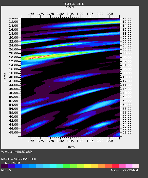
| Estimated Moho Depth: |
29.5 km |
| Estimated Crust Vp/Vs: |
1.69 |
| Assumed Crust Vp: |
6.264 km/s |
| Estimated Crust Vs: |
3.701 km/s |
| Estimated Crust Poisson's Ratio: |
0.23 |
|
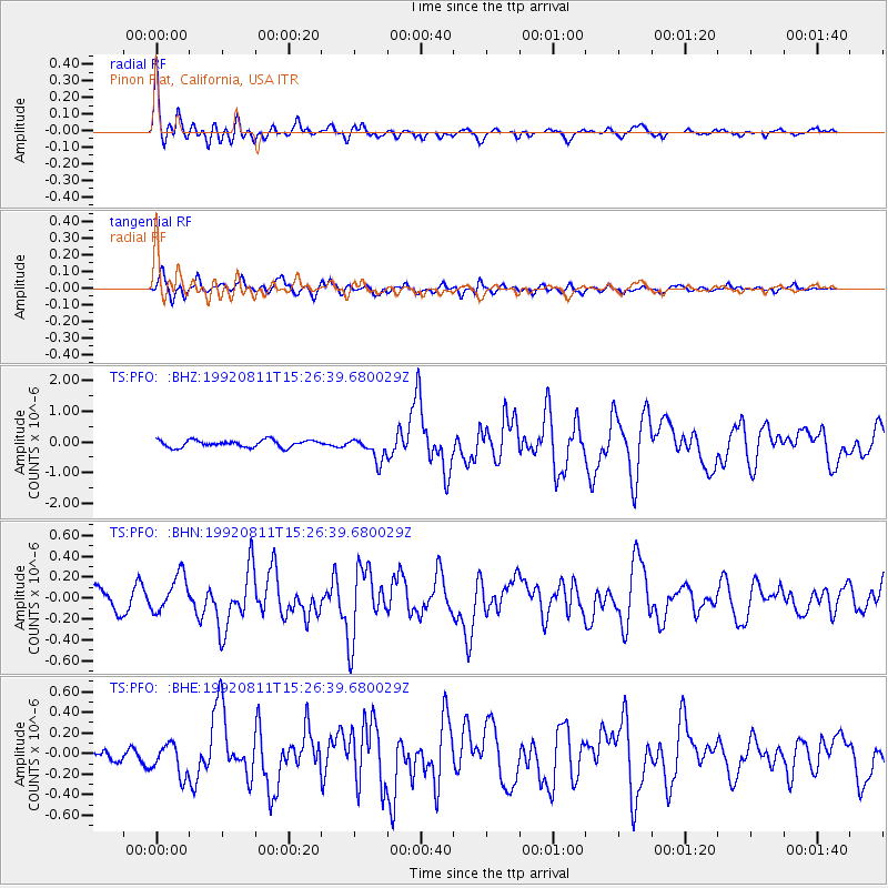
| Radial Match: |
86.51659 % |
| Radial Bump: |
400 |
| Transverse Match: |
68.829926 % |
| Transverse Bump: |
397 |
| SOD ConfigId: |
16938 |
| Insert Time: |
2010-02-26 14:41:53.424 +0000 |
| GWidth: |
2.5 |
| Max Bumps: |
400 |
| Tol: |
0.001 |
|
Signal To Noise
| Channel | StoN | STA | LTA |
| TS:PFO: :BHN:19920811T15:26:39.680029Z | 1.0595317 | 1.7534927E-7 | 1.6549696E-7 |
| TS:PFO: :BHE:19920811T15:26:39.680029Z | 2.351886 | 1.6024786E-7 | 6.8135904E-8 |
| TS:PFO: :BHZ:19920811T15:26:39.680029Z | 3.3201022 | 3.8347898E-7 | 1.1550216E-7 |
| Arrivals |
| Ps | 3.4 SECOND |
| PpPs | 12 SECOND |
| PsPs/PpSs | 16 SECOND |


