You are here: Home > Network List > TS - TERRAscope (Southern California Seismic Network) Stations List
> Station PFO Pinon Flat, California, USA > Earthquake Result Viewer
PFO Pinon Flat, California, USA - Earthquake Result Viewer
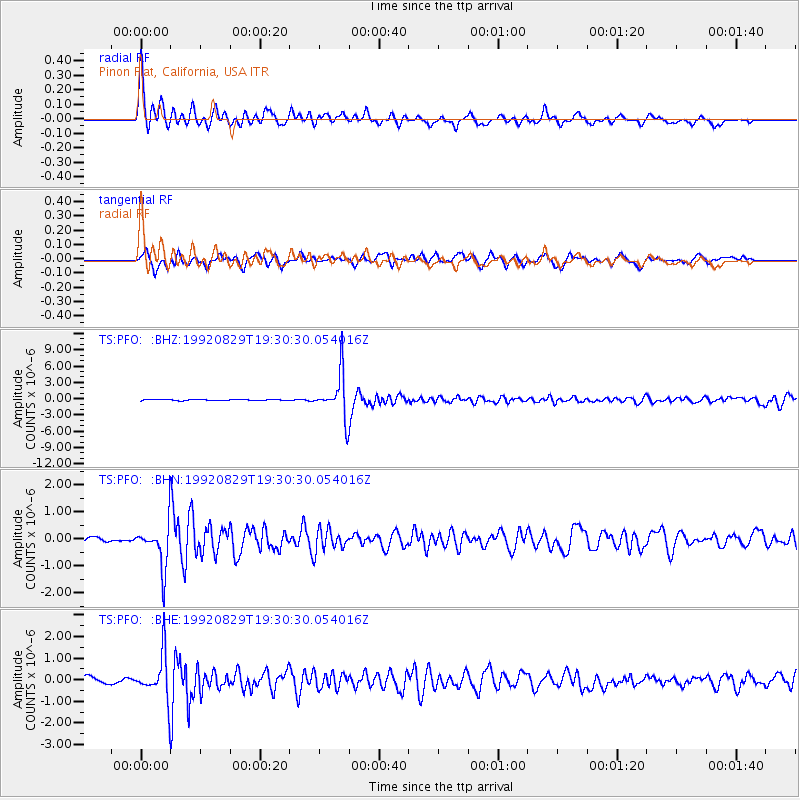
| Earthquake location: |
Southeast Of Honshu, Japan |
| Earthquake latitude/longitude: |
33.2/138.0 |
| Earthquake time(UTC): |
1992/08/29 (242) 19:19:07 GMT |
| Earthquake Depth: |
309 km |
| Earthquake Magnitude: |
6.0 MB |
| Earthquake Catalog/Contributor: |
WHDF/NEIC |
|
| Network: |
TS TERRAscope (Southern California Seismic Network) |
| Station: |
PFO Pinon Flat, California, USA |
| Lat/Lon: |
33.61 N/116.46 W |
| Elevation: |
1280 m |
|
| Distance: |
83.5 deg |
| Az: |
54.021 deg |
| Baz: |
305.569 deg |
| Ray Param: |
0.045323618 |
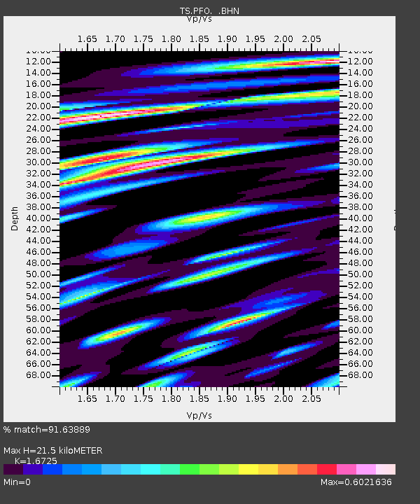
| Estimated Moho Depth: |
21.5 km |
| Estimated Crust Vp/Vs: |
1.67 |
| Assumed Crust Vp: |
6.264 km/s |
| Estimated Crust Vs: |
3.745 km/s |
| Estimated Crust Poisson's Ratio: |
0.22 |
|
| Radial Match: |
91.63889 % |
| Radial Bump: |
400 |
| Transverse Match: |
80.02931 % |
| Transverse Bump: |
400 |
| SOD ConfigId: |
16938 |
| Insert Time: |
2010-02-26 14:41:54.503 +0000 |
| GWidth: |
2.5 |
| Max Bumps: |
400 |
| Tol: |
0.001 |
|
Signal To Noise
| Channel | StoN | STA | LTA |
| TS:PFO: :BHN:19920829T19:30:30.054016Z | 9.303478 | 8.396166E-7 | 9.0247596E-8 |
| TS:PFO: :BHE:19920829T19:30:30.054016Z | 9.80614 | 1.0709601E-6 | 1.09213225E-7 |
| TS:PFO: :BHZ:19920829T19:30:30.054016Z | 40.578693 | 4.1161043E-6 | 1.01435106E-7 |
| Arrivals |
| Ps | 2.4 SECOND |
| PpPs | 8.9 SECOND |
| PsPs/PpSs | 11 SECOND |


