You are here: Home > Network List > TS - TERRAscope (Southern California Seismic Network) Stations List
> Station PFO Pinon Flat, California, USA > Earthquake Result Viewer
PFO Pinon Flat, California, USA - Earthquake Result Viewer
| Earthquake location: |
Vanuatu Islands |
| Earthquake latitude/longitude: |
-14.1/167.3 |
| Earthquake time(UTC): |
1992/09/15 (259) 21:04:00 GMT |
| Earthquake Depth: |
196 km |
| Earthquake Magnitude: |
6.1 MB |
| Earthquake Catalog/Contributor: |
WHDF/NEIC |
|
| Network: |
TS TERRAscope (Southern California Seismic Network) |
| Station: |
PFO Pinon Flat, California, USA |
| Lat/Lon: |
33.61 N/116.46 W |
| Elevation: |
1280 m |
|
| Distance: |
86.7 deg |
| Az: |
54.304 deg |
| Baz: |
250.752 deg |
| Ray Param: |
0.043436073 |
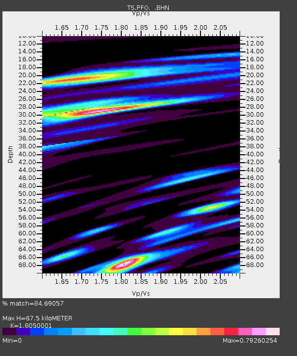
| Estimated Moho Depth: |
67.5 km |
| Estimated Crust Vp/Vs: |
1.81 |
| Assumed Crust Vp: |
6.264 km/s |
| Estimated Crust Vs: |
3.47 km/s |
| Estimated Crust Poisson's Ratio: |
0.28 |
|
| Radial Match: |
84.69057 % |
| Radial Bump: |
400 |
| Transverse Match: |
81.89273 % |
| Transverse Bump: |
400 |
| SOD ConfigId: |
16938 |
| Insert Time: |
2010-02-26 14:41:56.177 +0000 |
| GWidth: |
2.5 |
| Max Bumps: |
400 |
| Tol: |
0.001 |
|
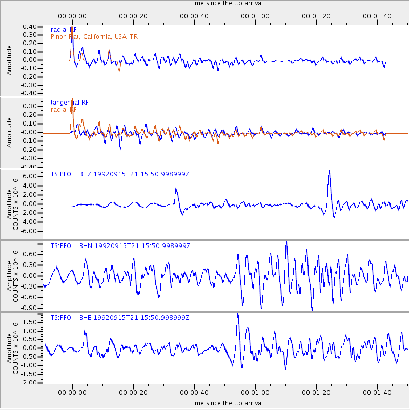
Signal To Noise
| Channel | StoN | STA | LTA |
| TS:PFO: :BHN:19920915T21:15:50.998999Z | 1.3567677 | 2.0894629E-7 | 1.54003E-7 |
| TS:PFO: :BHE:19920915T21:15:50.998999Z | 2.5034192 | 3.9531972E-7 | 1.5791193E-7 |
| TS:PFO: :BHZ:19920915T21:15:50.998999Z | 3.7990484 | 1.2746559E-6 | 3.355198E-7 |
| Arrivals |
| Ps | 8.9 SECOND |
| PpPs | 30 SECOND |
| PsPs/PpSs | 38 SECOND |


